

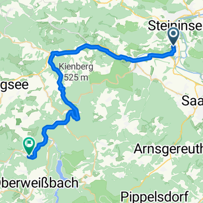
Aufnahme vom 7. Juni 14:43
A cycling route starting in Rudolstadt, Thuringia, Germany.
Overview
About this route
- 4 h 29 min
- Duration
- 51 km
- Distance
- 554 m
- Ascent
- 555 m
- Descent
- 11.4 km/h
- Avg. speed
- ---
- Max. altitude
Route quality
Waytypes & surfaces along the route
Waytypes
Track
21.4 km
(42 %)
Quiet road
9.2 km
(18 %)
Surfaces
Paved
18.4 km
(36 %)
Unpaved
27.1 km
(53 %)
Asphalt
16.8 km
(33 %)
Gravel
12.2 km
(24 %)
Route highlights
Points of interest along the route
Point of interest after 29.4 km

Point of interest after 29.4 km

Point of interest after 29.4 km

Point of interest after 29.4 km

Point of interest after 29.4 km

Point of interest after 29.7 km
Continue with Bikemap
Use, edit, or download this cycling route
You would like to ride Aufnahme vom 7. Juni 14:43 or customize it for your own trip? Here is what you can do with this Bikemap route:
Free features
- Save this route as favorite or in collections
- Copy & plan your own version of this route
- Sync your route with Garmin or Wahoo
Premium features
Free trial for 3 days, or one-time payment. More about Bikemap Premium.
- Navigate this route on iOS & Android
- Export a GPX / KML file of this route
- Create your custom printout (try it for free)
- Download this route for offline navigation
Discover more Premium features.
Get Bikemap PremiumFrom our community
Other popular routes starting in Rudolstadt
 Aufnahme vom 7. Juni 14:43
- Distance
- 51 km
- Ascent
- 554 m
- Descent
- 555 m
- Location
- Rudolstadt, Thuringia, Germany
 MTB Tour 5
- Distance
- 76.2 km
- Ascent
- 1,181 m
- Descent
- 1,149 m
- Location
- Rudolstadt, Thuringia, Germany
 Fröbelrundwanderweg
- Distance
- 27.3 km
- Ascent
- 432 m
- Descent
- 432 m
- Location
- Rudolstadt, Thuringia, Germany
 Ab durch den Wald.
- Distance
- 27.5 km
- Ascent
- 403 m
- Descent
- 405 m
- Location
- Rudolstadt, Thuringia, Germany
 Nach Remda und über die Herrenstraße zurück
- Distance
- 18.9 km
- Ascent
- 348 m
- Descent
- 348 m
- Location
- Rudolstadt, Thuringia, Germany
 Fahrradtour RU-Rottenbach-Bergbahn
- Distance
- 29.3 km
- Ascent
- 380 m
- Descent
- 263 m
- Location
- Rudolstadt, Thuringia, Germany
 RU-Oberweissbach-Solsdorf II
- Distance
- 82.5 km
- Ascent
- 1,219 m
- Descent
- 1,219 m
- Location
- Rudolstadt, Thuringia, Germany
 Auf dem Saale/Ilm und Klosterradweg
- Distance
- 53.5 km
- Ascent
- 462 m
- Descent
- 459 m
- Location
- Rudolstadt, Thuringia, Germany
Open it in the app