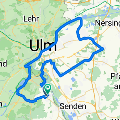
Senden-Greimeltshofen
A cycling route starting in Senden, Bavaria, Germany.
Overview
About this route
Senden-Vöhringen-Weissenhorn-Babenhausen-Greimeltshofen
- -:--
- Duration
- 42.9 km
- Distance
- 204 m
- Ascent
- 131 m
- Descent
- ---
- Avg. speed
- ---
- Max. altitude
Route quality
Waytypes & surfaces along the route
Waytypes
Path
19.3 km
(45 %)
Quiet road
9.4 km
(22 %)
Surfaces
Paved
36 km
(84 %)
Asphalt
35.6 km
(83 %)
Paved (undefined)
0.4 km
(1 %)
Undefined
6.9 km
(16 %)
Continue with Bikemap
Use, edit, or download this cycling route
You would like to ride Senden-Greimeltshofen or customize it for your own trip? Here is what you can do with this Bikemap route:
Free features
- Save this route as favorite or in collections
- Copy & plan your own version of this route
- Sync your route with Garmin or Wahoo
Premium features
Free trial for 3 days, or one-time payment. More about Bikemap Premium.
- Navigate this route on iOS & Android
- Export a GPX / KML file of this route
- Create your custom printout (try it for free)
- Download this route for offline navigation
Discover more Premium features.
Get Bikemap PremiumFrom our community
Other popular routes starting in Senden
- Ghfn-UL-Donau-GZ-Günz-Deisnhsn-Rogg-Whorn-Aufhm-Ghfn
- Distance
- 90 km
- Ascent
- 214 m
- Descent
- 216 m
- Location
- Senden, Bavaria, Germany
- Ehingen-Nasgenstadt
- Distance
- 58.5 km
- Ascent
- 397 m
- Descent
- 387 m
- Location
- Senden, Bavaria, Germany
- Um Ulm herum
- Distance
- 71.9 km
- Ascent
- 829 m
- Descent
- 1,310 m
- Location
- Senden, Bavaria, Germany
- rundweg
- Distance
- 44.1 km
- Ascent
- 51 m
- Descent
- 34 m
- Location
- Senden, Bavaria, Germany
- Rundtour: Aufheim - Weißenhorn - Roggenburg und zurück
- Distance
- 44.6 km
- Ascent
- 240 m
- Descent
- 241 m
- Location
- Senden, Bavaria, Germany
- Hüegelig
- Distance
- 60.5 km
- Ascent
- 480 m
- Descent
- 484 m
- Location
- Senden, Bavaria, Germany
- Donau Erbach Illertal
- Distance
- 64.7 km
- Ascent
- 376 m
- Descent
- 376 m
- Location
- Senden, Bavaria, Germany
- Vöhringen Route
- Distance
- 18.3 km
- Ascent
- 107 m
- Descent
- 591 m
- Location
- Senden, Bavaria, Germany
Open it in the app