

Rund um den Staffelsee
A cycling route starting in Wildsteig, Bavaria, Germany.
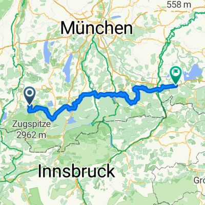
Overview
About this route
Bad Bayersoien Wanderparkplatz-Bad Kohlgrub-Murnau-Seehausen-Uffing.Über den oberen See-Harberg-Brand-Schöffau-Bad Bayersoien.
45km Höhenmeter 588 Mittlere Tour- -:--
- Duration
- 44.6 km
- Distance
- 317 m
- Ascent
- 327 m
- Descent
- ---
- Avg. speed
- ---
- Max. altitude
Route quality
Waytypes & surfaces along the route
Waytypes
Quiet road
21.3 km
(48 %)
Track
17.6 km
(39 %)
Surfaces
Paved
21 km
(47 %)
Unpaved
18.5 km
(42 %)
Asphalt
20.2 km
(45 %)
Gravel
11.9 km
(27 %)
Continue with Bikemap
Use, edit, or download this cycling route
You would like to ride Rund um den Staffelsee or customize it for your own trip? Here is what you can do with this Bikemap route:
Free features
- Save this route as favorite or in collections
- Copy & plan your own version of this route
- Sync your route with Garmin or Wahoo
Premium features
Free trial for 3 days, or one-time payment. More about Bikemap Premium.
- Navigate this route on iOS & Android
- Export a GPX / KML file of this route
- Create your custom printout (try it for free)
- Download this route for offline navigation
Discover more Premium features.
Get Bikemap PremiumFrom our community
Other popular routes starting in Wildsteig
 Wildsteig - Halblech
- Distance
- 25.9 km
- Ascent
- 503 m
- Descent
- 232 m
- Location
- Wildsteig, Bavaria, Germany
 Winterwanderung - Geizenmoos
- Distance
- 12.8 km
- Ascent
- 124 m
- Descent
- 125 m
- Location
- Wildsteig, Bavaria, Germany
 Planseerunde
- Distance
- 108.1 km
- Ascent
- 549 m
- Descent
- 546 m
- Location
- Wildsteig, Bavaria, Germany
 Große Rastrunde
- Distance
- 30.1 km
- Ascent
- 523 m
- Descent
- 523 m
- Location
- Wildsteig, Bavaria, Germany
 Groß Bicheleck
- Distance
- 13.6 km
- Ascent
- 237 m
- Descent
- 237 m
- Location
- Wildsteig, Bavaria, Germany
 Wildsteig-Unternogg-Wies
- Distance
- 29.8 km
- Ascent
- 496 m
- Descent
- 496 m
- Location
- Wildsteig, Bavaria, Germany
 Um die Wies
- Distance
- 26.3 km
- Ascent
- 332 m
- Descent
- 332 m
- Location
- Wildsteig, Bavaria, Germany
 Bodensee Königssee Radweg
- Distance
- 189 km
- Ascent
- 2,448 m
- Descent
- 2,720 m
- Location
- Wildsteig, Bavaria, Germany
Open it in the app