Kottenforst Ville-Seen Radweg
A cycling route starting in Neustadt/Nord, North Rhine-Westphalia, Germany.
Overview
About this route
Die in Jahrhunderten geprägten Feldfluren, Wälder und dörflichen Siedlungen mussten dem Tagebau weichen.Im Zuge der Rekultivierung entstanden weite, ebene Feldfluren mit Einzelhöfen und kleinen Weilern, junge Laubwälder, neue Biotope und Landschaftsseen entstanden.
- -:--
- Duration
- 60.3 km
- Distance
- 177 m
- Ascent
- 184 m
- Descent
- ---
- Avg. speed
- ---
- Avg. speed
Route quality
Waytypes & surfaces along the route
Waytypes
Path
19.3 km
(32 %)
Track
18.8 km
(31 %)
Surfaces
Paved
34.3 km
(57 %)
Unpaved
21.7 km
(36 %)
Asphalt
29.3 km
(49 %)
Gravel
16.1 km
(27 %)
Route highlights
Points of interest along the route
Accommodation after 28.1 km
Seeklaus Heider Bergsee 1b, 50321 Brühl Telefon: 02232 1502825 Mi. 10:00 - 22:00
Accommodation after 33.7 km
Alt Liblar Carl-Schurz-Straße 8, 50374 Erftstadt 02235 463333 Öffnungszeiten: Mittwoch 11:30–14:30
Continue with Bikemap
Use, edit, or download this cycling route
You would like to ride Kottenforst Ville-Seen Radweg or customize it for your own trip? Here is what you can do with this Bikemap route:
Free features
- Save this route as favorite or in collections
- Copy & plan your own version of this route
- Sync your route with Garmin or Wahoo
Premium features
Free trial for 3 days, or one-time payment. More about Bikemap Premium.
- Navigate this route on iOS & Android
- Export a GPX / KML file of this route
- Create your custom printout (try it for free)
- Download this route for offline navigation
Discover more Premium features.
Get Bikemap PremiumFrom our community
Other popular routes starting in Neustadt/Nord
- Kottenforst Ville-Seen Radweg
- Distance
- 60.3 km
- Ascent
- 177 m
- Descent
- 184 m
- Location
- Neustadt/Nord, North Rhine-Westphalia, Germany
- Stommeln Windmühlen
- Distance
- 60.3 km
- Ascent
- 85 m
- Descent
- 83 m
- Location
- Neustadt/Nord, North Rhine-Westphalia, Germany
- Schloss Paffendorf
- Distance
- 61.9 km
- Ascent
- 284 m
- Descent
- 286 m
- Location
- Neustadt/Nord, North Rhine-Westphalia, Germany
- Köln Promenade
- Distance
- 18.8 km
- Ascent
- 153 m
- Descent
- 173 m
- Location
- Neustadt/Nord, North Rhine-Westphalia, Germany
- Schloßpark Dyck
- Distance
- 64.1 km
- Ascent
- 112 m
- Descent
- 115 m
- Location
- Neustadt/Nord, North Rhine-Westphalia, Germany
- Kölnrunde
- Distance
- 34.3 km
- Ascent
- 115 m
- Descent
- 112 m
- Location
- Neustadt/Nord, North Rhine-Westphalia, Germany
- Blumenthalstraße - Fühlinger See
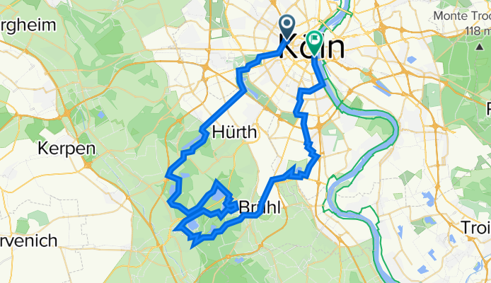
- Distance
- 33.7 km
- Ascent
- 96 m
- Descent
- 135 m
- Location
- Neustadt/Nord, North Rhine-Westphalia, Germany
- Route nach Arnhem
- Distance
- 173.9 km
- Ascent
- 278 m
- Descent
- 321 m
- Location
- Neustadt/Nord, North Rhine-Westphalia, Germany
Open it in the app