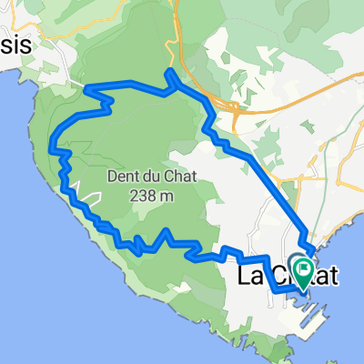
la ciotat - bandol
A cycling route starting in La Ciotat, Provence-Alpes-Côte d'Azur Region, France.
Overview
About this route
09/06/15 7:41
- -:--
- Duration
- 37.3 km
- Distance
- 349 m
- Ascent
- 349 m
- Descent
- ---
- Avg. speed
- ---
- Max. altitude
Route quality
Waytypes & surfaces along the route
Waytypes
Busy road
30.3 km
(81 %)
Road
4.5 km
(12 %)
Surfaces
Paved
30.9 km
(83 %)
Asphalt
30.1 km
(81 %)
Paving stones
0.7 km
(2 %)
Continue with Bikemap
Use, edit, or download this cycling route
You would like to ride la ciotat - bandol or customize it for your own trip? Here is what you can do with this Bikemap route:
Free features
- Save this route as favorite or in collections
- Copy & plan your own version of this route
- Sync your route with Garmin or Wahoo
Premium features
Free trial for 3 days, or one-time payment. More about Bikemap Premium.
- Navigate this route on iOS & Android
- Export a GPX / KML file of this route
- Create your custom printout (try it for free)
- Download this route for offline navigation
Discover more Premium features.
Get Bikemap PremiumFrom our community
Other popular routes starting in La Ciotat
- Cassis - Ciotat 10 km
- Distance
- 10 km
- Ascent
- 331 m
- Descent
- 307 m
- Location
- La Ciotat, Provence-Alpes-Côte d'Azur Region, France
- La Ciotat kleine Runde
- Distance
- 15.2 km
- Ascent
- 450 m
- Descent
- 427 m
- Location
- La Ciotat, Provence-Alpes-Côte d'Azur Region, France
- 30-10-2016
- Distance
- 19.2 km
- Ascent
- 496 m
- Descent
- 495 m
- Location
- La Ciotat, Provence-Alpes-Côte d'Azur Region, France
- port d'alons
- Distance
- 47.4 km
- Ascent
- 497 m
- Descent
- 496 m
- Location
- La Ciotat, Provence-Alpes-Côte d'Azur Region, France
- VeloPokerTour2014 J17 La Ciotat Le Pradet
- Distance
- 64.4 km
- Ascent
- 470 m
- Descent
- 460 m
- Location
- La Ciotat, Provence-Alpes-Côte d'Azur Region, France
- La Ciotat Roquefort cassis and back
- Distance
- 32 km
- Ascent
- 531 m
- Descent
- 529 m
- Location
- La Ciotat, Provence-Alpes-Côte d'Azur Region, France
- Medium length evening ride
- Distance
- 42.4 km
- Ascent
- 901 m
- Descent
- 901 m
- Location
- La Ciotat, Provence-Alpes-Côte d'Azur Region, France
- 01- Départ par St Cyr - Bandol - les gorges de Ollioules, Le Beausset, Le Brulat,St Cyr
- Distance
- 61.9 km
- Ascent
- 797 m
- Descent
- 758 m
- Location
- La Ciotat, Provence-Alpes-Côte d'Azur Region, France
Open it in the app