

work
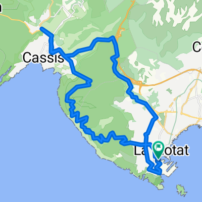
A cycling route starting in La Ciotat, Provence-Alpes-Côte d'Azur Region, France.
Overview
About this route
09/06/15 15:12
- -:--
- Duration
- 5.7 km
- Distance
- 145 m
- Ascent
- 16 m
- Descent
- ---
- Avg. speed
- ---
- Max. altitude
Route quality
Waytypes & surfaces along the route
Waytypes
Quiet road
2.3 km
(41 %)
Road
2.1 km
(37 %)
Surfaces
Paved
3 km
(53 %)
Asphalt
3 km
(53 %)
Undefined
2.7 km
(47 %)
Continue with Bikemap
Use, edit, or download this cycling route
You would like to ride work or customize it for your own trip? Here is what you can do with this Bikemap route:
Free features
- Save this route as favorite or in collections
- Copy & plan your own version of this route
- Sync your route with Garmin or Wahoo
Premium features
Free trial for 3 days, or one-time payment. More about Bikemap Premium.
- Navigate this route on iOS & Android
- Export a GPX / KML file of this route
- Create your custom printout (try it for free)
- Download this route for offline navigation
Discover more Premium features.
Get Bikemap PremiumFrom our community
Other popular routes starting in La Ciotat
 01- Départ par St Cyr - Bandol - les gorges de Ollioules, Le Beausset, Le Brulat,St Cyr
- Distance
- 61.9 km
- Ascent
- 797 m
- Descent
- 758 m
- Location
- La Ciotat, Provence-Alpes-Côte d'Azur Region, France
 la ciotat -casis route crete
- Distance
- 29.8 km
- Ascent
- 672 m
- Descent
- 672 m
- Location
- La Ciotat, Provence-Alpes-Côte d'Azur Region, France
 VeloPokerTour2014 J17 La Ciotat Le Pradet
- Distance
- 64.4 km
- Ascent
- 470 m
- Descent
- 460 m
- Location
- La Ciotat, Provence-Alpes-Côte d'Azur Region, France
 Medium length evening ride
- Distance
- 42.4 km
- Ascent
- 901 m
- Descent
- 901 m
- Location
- La Ciotat, Provence-Alpes-Côte d'Azur Region, France
 Cassis - Ciotat 10 km
- Distance
- 10 km
- Ascent
- 331 m
- Descent
- 307 m
- Location
- La Ciotat, Provence-Alpes-Côte d'Azur Region, France
 la ciotat - bandol
- Distance
- 37.3 km
- Ascent
- 349 m
- Descent
- 349 m
- Location
- La Ciotat, Provence-Alpes-Côte d'Azur Region, France
 port d'alons
- Distance
- 47.4 km
- Ascent
- 497 m
- Descent
- 496 m
- Location
- La Ciotat, Provence-Alpes-Côte d'Azur Region, France
 La Ciotat Roquefort cassis and back
- Distance
- 32 km
- Ascent
- 531 m
- Descent
- 529 m
- Location
- La Ciotat, Provence-Alpes-Côte d'Azur Region, France
Open it in the app