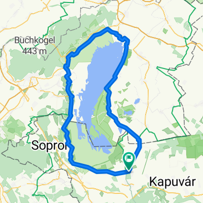
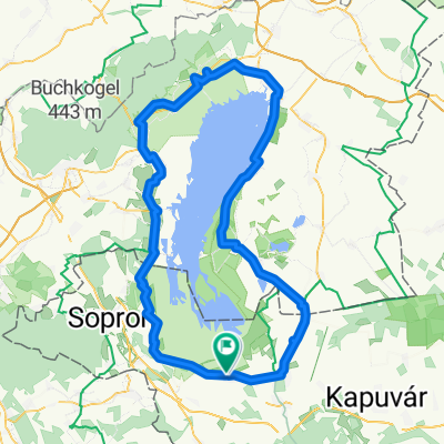
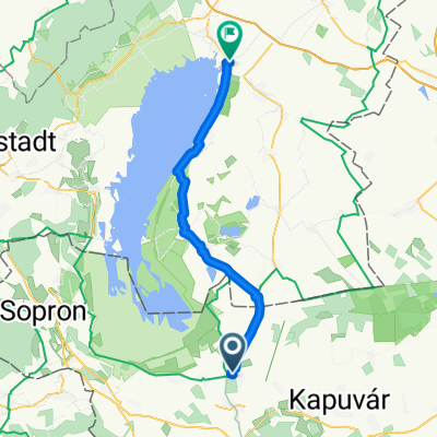
Fertő-tó - Balaton kerékpáros útvonal
A cycling route starting in Fertőd, Győr-Moson-Sopron, Hungary.
Overview
About this route
Fertő-tó - Balaton kerékpáros útvonal
- -:--
- Duration
- 129.2 km
- Distance
- 266 m
- Ascent
- 283 m
- Descent
- ---
- Avg. speed
- ---
- Max. altitude
Route quality
Waytypes & surfaces along the route
Waytypes
Busy road
87.7 km
(68 %)
Quiet road
14.2 km
(11 %)
Surfaces
Paved
58.2 km
(45 %)
Unpaved
3.2 km
(2 %)
Asphalt
54.5 km
(42 %)
Paving stones
3.7 km
(3 %)
Route highlights
Points of interest along the route
Photo after 40 km
Nádasdy-vár
Photo after 41.4 km
Gyógy- és wellnessfürdő Sárvár
Photo after 62.3 km
Kemenes Vulkánpark Látogatóközpont
Photo after 67.8 km
Termálfürdő
Photo after 72.8 km
Termálfürdő
Photo after 73 km
Berzsenyi Dániel Emlékház
Photo after 106.8 km
Bazaltfolyosó
Photo after 109.3 km
Vindornya-láp
Photo after 111.2 km
Kehida Termál Gyógy- és Élményfürdő
Photo after 114.9 km
Rezi vár
Photo after 122.1 km
Hévízi Tófürdő
Photo after 127.1 km
Georgikon Majormúzeum
Photo after 127.6 km
Festetics-kastély
Photo after 127.7 km
Belvárosi Múzeumok
Photo after 128.2 km
Balatoni Múzeum
Continue with Bikemap
Use, edit, or download this cycling route
You would like to ride Fertő-tó - Balaton kerékpáros útvonal or customize it for your own trip? Here is what you can do with this Bikemap route:
Free features
- Save this route as favorite or in collections
- Copy & plan your own version of this route
- Split it into stages to create a multi-day tour
- Sync your route with Garmin or Wahoo
Premium features
Free trial for 3 days, or one-time payment. More about Bikemap Premium.
- Navigate this route on iOS & Android
- Export a GPX / KML file of this route
- Create your custom printout (try it for free)
- Download this route for offline navigation
Discover more Premium features.
Get Bikemap PremiumFrom our community
Other popular routes starting in Fertőd
- Route to Fertőd
- Distance
- 115.1 km
- Ascent
- 468 m
- Descent
- 468 m
- Location
- Fertőd, Győr-Moson-Sopron, Hungary
- Fertő tó kerülés
- Distance
- 112.3 km
- Ascent
- 134 m
- Descent
- 134 m
- Location
- Fertőd, Győr-Moson-Sopron, Hungary
- Neusiedlerseerunde/Austria-Ungarn
- Distance
- 118.2 km
- Ascent
- 148 m
- Descent
- 149 m
- Location
- Fertőd, Győr-Moson-Sopron, Hungary
- Túra Írot-kőre 2012 - rossz
- Distance
- 177.6 km
- Ascent
- 982 m
- Descent
- 982 m
- Location
- Fertőd, Győr-Moson-Sopron, Hungary
- Sarród-Apethlon-St.Andrä-Podersdorf-Illmitz-Apethlon-Sarród (némi tervezetlen kitérőkkel)
- Distance
- 91.8 km
- Ascent
- 627 m
- Descent
- 630 m
- Location
- Fertőd, Győr-Moson-Sopron, Hungary
- 1/4 Fertő tó*2
- Distance
- 60.1 km
- Ascent
- 186 m
- Descent
- 186 m
- Location
- Fertőd, Győr-Moson-Sopron, Hungary
- Fertő tó kör
- Distance
- 111.1 km
- Ascent
- 439 m
- Descent
- 446 m
- Location
- Fertőd, Győr-Moson-Sopron, Hungary
- 1102 NEZIDERSKÉ JEZERO, HRADY, VÍNO A TERMÁLY NA KOLE
- Distance
- 158.3 km
- Ascent
- 392 m
- Descent
- 388 m
- Location
- Fertőd, Győr-Moson-Sopron, Hungary
Open it in the app