

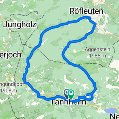
Tour Strinden Alpe
A cycling route starting in Tannheim, Tyrol, Austria.
Overview
About this route
From Tannheim to Strindenalpe
- -:--
- Duration
- 23.7 km
- Distance
- 948 m
- Ascent
- 948 m
- Descent
- ---
- Avg. speed
- ---
- Max. altitude
Continue with Bikemap
Use, edit, or download this cycling route
You would like to ride Tour Strinden Alpe or customize it for your own trip? Here is what you can do with this Bikemap route:
Free features
- Save this route as favorite or in collections
- Copy & plan your own version of this route
- Sync your route with Garmin or Wahoo
Premium features
Free trial for 3 days, or one-time payment. More about Bikemap Premium.
- Navigate this route on iOS & Android
- Export a GPX / KML file of this route
- Create your custom printout (try it for free)
- Download this route for offline navigation
Discover more Premium features.
Get Bikemap PremiumFrom our community
Other popular routes starting in Tannheim
 Tour 2013 Auf König LudwigsSpuren mittel
- Distance
- 69.7 km
- Ascent
- 679 m
- Descent
- 679 m
- Location
- Tannheim, Tyrol, Austria
 vilstalrunde
- Distance
- 36.2 km
- Ascent
- 678 m
- Descent
- 679 m
- Location
- Tannheim, Tyrol, Austria
 Tannheim - Füssen - Neuschwanstein - Pfronten - Tannheim
- Distance
- 78.6 km
- Ascent
- 481 m
- Descent
- 482 m
- Location
- Tannheim, Tyrol, Austria
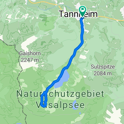 Von Tannheim zum Vilsalpsee
- Distance
- 13.8 km
- Ascent
- 0 m
- Descent
- 0 m
- Location
- Tannheim, Tyrol, Austria
 Tour Strinden Alpe
- Distance
- 23.7 km
- Ascent
- 948 m
- Descent
- 948 m
- Location
- Tannheim, Tyrol, Austria
 Höf 1, Tannheim nach Tannheimer Straße
- Distance
- 75.5 km
- Ascent
- 1,367 m
- Descent
- 1,344 m
- Location
- Tannheim, Tyrol, Austria
 RSC TTal - Tannheim - Breitenstein
- Distance
- 45.6 km
- Ascent
- 1,160 m
- Descent
- 1,159 m
- Location
- Tannheim, Tyrol, Austria
 RSC TTal - 2 Seen Tour
- Distance
- 27.1 km
- Ascent
- 369 m
- Descent
- 369 m
- Location
- Tannheim, Tyrol, Austria
Open it in the app