
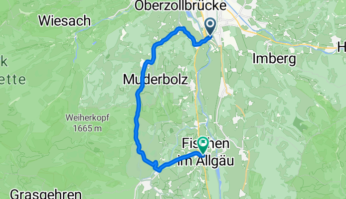
Sonthofen-Fischen über Dörfer ca. 40 min
A cycling route starting in Sonthofen, Bavaria, Germany.
Overview
About this route
<span style="color: #000000; font-family: Helvetica; font-size: medium;">Zeit ca. 30 - 40 min<br /> <table border="0"> <tbody> <tr> <td>Strecke:</td> <td>12.6 km</td> </tr> <tr> <td>Kalorien:</td> <td>811 kcal</td> </tr> <tr> <td>Mittlere Geschw.:</td> <td>17.3 km/h</td> </tr> <tr> <td>Höhenmeter:</td> <td>
171 m
by iPhone App. B.iCycle </td> </tr> </tbody> </table> </span>
- -:--
- Duration
- 12.6 km
- Distance
- 214 m
- Ascent
- 190 m
- Descent
- ---
- Avg. speed
- ---
- Avg. speed
Continue with Bikemap
Use, edit, or download this cycling route
You would like to ride Sonthofen-Fischen über Dörfer ca. 40 min or customize it for your own trip? Here is what you can do with this Bikemap route:
Free features
- Save this route as favorite or in collections
- Copy & plan your own version of this route
- Sync your route with Garmin or Wahoo
Premium features
Free trial for 3 days, or one-time payment. More about Bikemap Premium.
- Navigate this route on iOS & Android
- Export a GPX / KML file of this route
- Create your custom printout (try it for free)
- Download this route for offline navigation
Discover more Premium features.
Get Bikemap PremiumFrom our community
Other popular routes starting in Sonthofen
 Dreiangelhütte
- Distance
- 25.4 km
- Ascent
- 722 m
- Descent
- 728 m
- Location
- Sonthofen, Bavaria, Germany
 Allgäu-Oberjoch-Tannheimer Tal
- Distance
- 87.4 km
- Ascent
- 953 m
- Descent
- 953 m
- Location
- Sonthofen, Bavaria, Germany
 D_SüdBayern_Sonthofen: "Allgaeu Panorama Marathon"
- Distance
- 41.5 km
- Ascent
- 1,134 m
- Descent
- 1,133 m
- Location
- Sonthofen, Bavaria, Germany
 Sonthofer und Altstädter Hof
- Distance
- 21.6 km
- Ascent
- 698 m
- Descent
- 696 m
- Location
- Sonthofen, Bavaria, Germany
 RSCH Alpentraum 2014
- Distance
- 221.1 km
- Ascent
- 3,888 m
- Descent
- 2,789 m
- Location
- Sonthofen, Bavaria, Germany
 Bergkäs Runde Oberallgäu - Bregenzer Wald
- Distance
- 71.3 km
- Ascent
- 987 m
- Descent
- 989 m
- Location
- Sonthofen, Bavaria, Germany
 einfache Talrunde (mit Altst.-Hof)
- Distance
- 33.7 km
- Ascent
- 824 m
- Descent
- 821 m
- Location
- Sonthofen, Bavaria, Germany
 Sonthofen Schrofenpass Lechtal
- Distance
- 58.2 km
- Ascent
- 971 m
- Descent
- 650 m
- Location
- Sonthofen, Bavaria, Germany
Open it in the app