

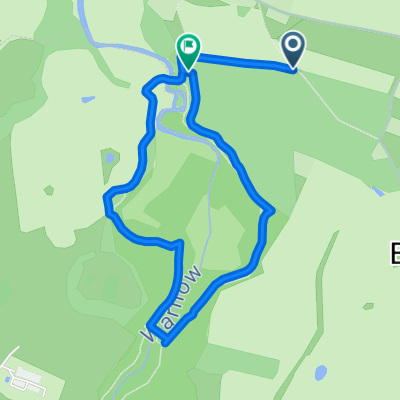
Warnowtal hügelige Waldwanderung 1Stunde
A cycling route starting in Warnow, Mecklenburg-Vorpommern, Germany.
Overview
About this route
13km von boitin Die Wanderung durch das Warnow - Mildenitz - Durchbruchtal beginnt auf dem Parkplatz am Waldrand von Klein Raden. Rechts am Waldrand vorbei, gehen Sie durch den Hohlweg und folgen dann den Weg links in den Wald. Die Warnow fließt zu Ihrer Rechten. Über einige Steigungen und leichten Abstiege, wandern Sie in Richtung Groß Görnow weiter und erreichen die Brücke über die Warnow. Nach deren Überquerung führt Sie rechts der Rundweg weiter, links geht es nach Groß Görnow. Lohnenswert ist ein Gang zur Anhöhe hinauf, zu der ehemaligen Burgwallanlage.
- -:--
- Duration
- 3.2 km
- Distance
- 71 m
- Ascent
- 83 m
- Descent
- ---
- Avg. speed
- ---
- Max. altitude
Continue with Bikemap
Use, edit, or download this cycling route
You would like to ride Warnowtal hügelige Waldwanderung 1Stunde or customize it for your own trip? Here is what you can do with this Bikemap route:
Free features
- Save this route as favorite or in collections
- Copy & plan your own version of this route
- Sync your route with Garmin or Wahoo
Premium features
Free trial for 3 days, or one-time payment. More about Bikemap Premium.
- Navigate this route on iOS & Android
- Export a GPX / KML file of this route
- Create your custom printout (try it for free)
- Download this route for offline navigation
Discover more Premium features.
Get Bikemap PremiumFrom our community
Other popular routes starting in Warnow
 wismar
- Distance
- 42 km
- Ascent
- 262 m
- Descent
- 295 m
- Location
- Warnow, Mecklenburg-Vorpommern, Germany
 Warnowtal hügelige Waldwanderung 1Stunde
- Distance
- 3.2 km
- Ascent
- 71 m
- Descent
- 83 m
- Location
- Warnow, Mecklenburg-Vorpommern, Germany
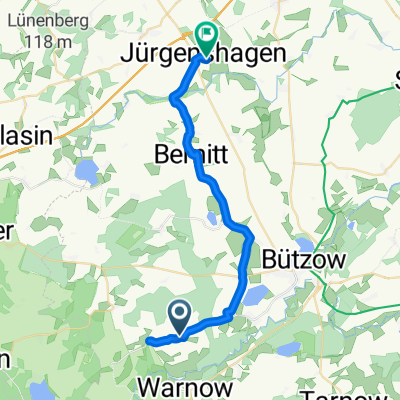 Lindenstraße, Baumgarten nach Am Sportplatz, Jürgenshagen
- Distance
- 25.5 km
- Ascent
- 195 m
- Descent
- 226 m
- Location
- Warnow, Mecklenburg-Vorpommern, Germany
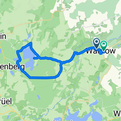
 groß raden
- Distance
- 7.5 km
- Ascent
- 86 m
- Descent
- 98 m
- Location
- Warnow, Mecklenburg-Vorpommern, Germany
 Dorfstraße 1, Warnow nach Fritz-Reuter-Straße 32, Hohen Viecheln
- Distance
- 105.9 km
- Ascent
- 1,137 m
- Descent
- 1,093 m
- Location
- Warnow, Mecklenburg-Vorpommern, Germany
 Neubaugebiet 99, Warnow nach Güstrower Landweg 42, Warnow
- Distance
- 28.7 km
- Ascent
- 6 m
- Descent
- 28 m
- Location
- Warnow, Mecklenburg-Vorpommern, Germany
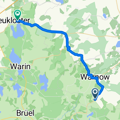 Gemütliche Route in Neukloster
- Distance
- 23 km
- Ascent
- 225 m
- Descent
- 212 m
- Location
- Warnow, Mecklenburg-Vorpommern, Germany
 Unnamed Road, Warnow nach Bahnhofstraße 37, Techentin
- Distance
- 33.2 km
- Ascent
- 491 m
- Descent
- 436 m
- Location
- Warnow, Mecklenburg-Vorpommern, Germany
Open it in the app