

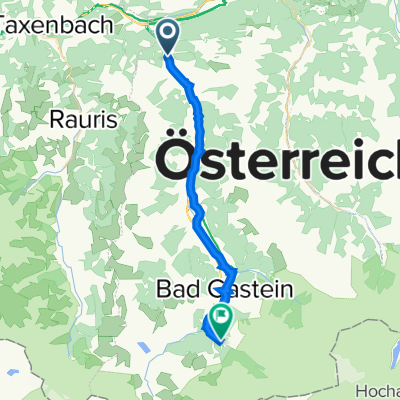
Zell am See - Lend
A cycling route starting in Lend, Salzburg, Austria.
Overview
About this route
Part of the Tauern Cycle Path
(cloned from route 2374741)
- -:--
- Duration
- 22 km
- Distance
- 213 m
- Ascent
- 98 m
- Descent
- ---
- Avg. speed
- ---
- Max. altitude
Route quality
Waytypes & surfaces along the route
Waytypes
Quiet road
7.5 km
(34 %)
Path
5 km
(23 %)
Surfaces
Paved
20.2 km
(92 %)
Unpaved
0.4 km
(2 %)
Asphalt
19.3 km
(88 %)
Paved (undefined)
0.9 km
(4 %)
Continue with Bikemap
Use, edit, or download this cycling route
You would like to ride Zell am See - Lend or customize it for your own trip? Here is what you can do with this Bikemap route:
Free features
- Save this route as favorite or in collections
- Copy & plan your own version of this route
- Sync your route with Garmin or Wahoo
Premium features
Free trial for 3 days, or one-time payment. More about Bikemap Premium.
- Navigate this route on iOS & Android
- Export a GPX / KML file of this route
- Create your custom printout (try it for free)
- Download this route for offline navigation
Discover more Premium features.
Get Bikemap PremiumFrom our community
Other popular routes starting in Lend
 Ciclovia Alpe-Adria - Teil 2
- Distance
- 27.3 km
- Ascent
- 415 m
- Descent
- 63 m
- Location
- Lend, Salzburg, Austria
 Zell am See - Lend
- Distance
- 22 km
- Ascent
- 213 m
- Descent
- 98 m
- Location
- Lend, Salzburg, Austria
 Lengthy ride through Goldegg
- Distance
- 43.1 km
- Ascent
- 1,433 m
- Descent
- 1,434 m
- Location
- Lend, Salzburg, Austria
 Klammstein 14, Dorfgastein à Kaiserhofstraße 7, Bad Gastein
- Distance
- 20.4 km
- Ascent
- 254 m
- Descent
- 97 m
- Location
- Lend, Salzburg, Austria
 Alpe Adria 2a
- Distance
- 26.8 km
- Ascent
- 493 m
- Descent
- 150 m
- Location
- Lend, Salzburg, Austria
 ride through Goldegg
- Distance
- 10.8 km
- Ascent
- 281 m
- Descent
- 281 m
- Location
- Lend, Salzburg, Austria
 Dienten - Maria Alm - Zell/See - Salzachtal
- Distance
- 67.4 km
- Ascent
- 757 m
- Descent
- 757 m
- Location
- Lend, Salzburg, Austria
 Taxenbach - Dorf Gastein Teil 1 (Tunnelumgehung)
- Distance
- 9.8 km
- Ascent
- 727 m
- Descent
- 536 m
- Location
- Lend, Salzburg, Austria
Open it in the app