

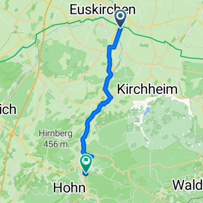
EU-Bleibtreusee-EU
A cycling route starting in Euskirchen, North Rhine-Westphalia, Germany.
Overview
About this route
Country roads, few streets, forest paths - all easily accessible for trekking or mountain bikes: From Euskirchen to Bleibtreusee, a jump in the water and back on a different path. Have fun.
- -:--
- Duration
- 58.2 km
- Distance
- 186 m
- Ascent
- 182 m
- Descent
- ---
- Avg. speed
- ---
- Max. altitude

Continue with Bikemap
Use, edit, or download this cycling route
You would like to ride EU-Bleibtreusee-EU or customize it for your own trip? Here is what you can do with this Bikemap route:
Free features
- Save this route as favorite or in collections
- Copy & plan your own version of this route
- Sync your route with Garmin or Wahoo
Premium features
Free trial for 3 days, or one-time payment. More about Bikemap Premium.
- Navigate this route on iOS & Android
- Export a GPX / KML file of this route
- Create your custom printout (try it for free)
- Download this route for offline navigation
Discover more Premium features.
Get Bikemap PremiumFrom our community
Other popular routes starting in Euskirchen
 Jahnstraße 1I nach Jahnstraße
- Distance
- 23.9 km
- Ascent
- 175 m
- Descent
- 223 m
- Location
- Euskirchen, North Rhine-Westphalia, Germany
 Von Euskirchen bis Sankt Augustin
- Distance
- 40.3 km
- Ascent
- 95 m
- Descent
- 204 m
- Location
- Euskirchen, North Rhine-Westphalia, Germany
 Euskirchen- Aachen Altstr.54
- Distance
- 79.4 km
- Ascent
- 324 m
- Descent
- 304 m
- Location
- Euskirchen, North Rhine-Westphalia, Germany
 Euskirchen - Jülich + Jülich - Aachen
- Distance
- 47.5 km
- Ascent
- 556 m
- Descent
- 628 m
- Location
- Euskirchen, North Rhine-Westphalia, Germany
 Euskirchen Eifelrunde1
- Distance
- 69.2 km
- Ascent
- 814 m
- Descent
- 726 m
- Location
- Euskirchen, North Rhine-Westphalia, Germany
 7_Stotzenheim - Bad Münstereifel
- Distance
- 15.3 km
- Ascent
- 332 m
- Descent
- 127 m
- Location
- Euskirchen, North Rhine-Westphalia, Germany
 Rodderbach 55, Euskirchen nach Rodderbach 55, Euskirchen
- Distance
- 19.1 km
- Ascent
- 160 m
- Descent
- 157 m
- Location
- Euskirchen, North Rhine-Westphalia, Germany
 Durch die Felder zwischen EU,Z und WW
- Distance
- 31.9 km
- Ascent
- 93 m
- Descent
- 93 m
- Location
- Euskirchen, North Rhine-Westphalia, Germany
Open it in the app