

20150612_223323.gpx
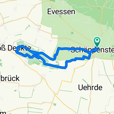
A cycling route starting in Schöppenstedt, Lower Saxony, Germany.
Overview
About this route
TEASI track
- -:--
- Duration
- 20.3 km
- Distance
- 44 m
- Ascent
- 78 m
- Descent
- ---
- Avg. speed
- ---
- Max. altitude

Route quality
Waytypes & surfaces along the route
Waytypes
Track
9.3 km
(46 %)
Quiet road
3.6 km
(18 %)
Surfaces
Paved
15 km
(74 %)
Unpaved
2 km
(10 %)
Asphalt
10.3 km
(51 %)
Paved (undefined)
4.7 km
(23 %)
Continue with Bikemap
Use, edit, or download this cycling route
You would like to ride 20150612_223323.gpx or customize it for your own trip? Here is what you can do with this Bikemap route:
Free features
- Save this route as favorite or in collections
- Copy & plan your own version of this route
- Sync your route with Garmin or Wahoo
Premium features
Free trial for 3 days, or one-time payment. More about Bikemap Premium.
- Navigate this route on iOS & Android
- Export a GPX / KML file of this route
- Create your custom printout (try it for free)
- Download this route for offline navigation
Discover more Premium features.
Get Bikemap PremiumFrom our community
Other popular routes starting in Schöppenstedt
 Kaiserdom-Route
- Distance
- 47.7 km
- Ascent
- 554 m
- Descent
- 555 m
- Location
- Schöppenstedt, Lower Saxony, Germany
 Große Feierabendrunde
- Distance
- 78.3 km
- Ascent
- 374 m
- Descent
- 374 m
- Location
- Schöppenstedt, Lower Saxony, Germany
 Asse 01 (Bismarckturm)
- Distance
- 30.6 km
- Ascent
- 336 m
- Descent
- 336 m
- Location
- Schöppenstedt, Lower Saxony, Germany
 ¿?Ä?? nach ¿?Ä??
- Distance
- 51.3 km
- Ascent
- 435 m
- Descent
- 435 m
- Location
- Schöppenstedt, Lower Saxony, Germany
 Radwandern 2011-09-07 Schöppenstedt - Helmstedt
- Distance
- 40.1 km
- Ascent
- 268 m
- Descent
- 229 m
- Location
- Schöppenstedt, Lower Saxony, Germany
 Green Belt - Stage 17
- Distance
- 74.1 km
- Ascent
- 343 m
- Descent
- 323 m
- Location
- Schöppenstedt, Lower Saxony, Germany
 MTB Elm Schöppenstedt 1 Rundtour über Eitzum zum Tetzelstein
- Distance
- 25.9 km
- Ascent
- 302 m
- Descent
- 303 m
- Location
- Schöppenstedt, Lower Saxony, Germany
 MTB Elm Schöppenstedt 1 Rundtour über Eitzum zum Tetzelstein
- Distance
- 25.9 km
- Ascent
- 335 m
- Descent
- 281 m
- Location
- Schöppenstedt, Lower Saxony, Germany
Open it in the app