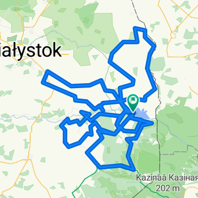
etap 6
A cycling route starting in MichaĆowo, Podlasie Voivodship, Poland.
Overview
About this route
w trakcie
- -:--
- Duration
- 132.5 km
- Distance
- 236 m
- Ascent
- 247 m
- Descent
- ---
- Avg. speed
- ---
- Avg. speed
Route quality
Waytypes & surfaces along the route
Waytypes
Busy road
89.9 km
(68 %)
Path
22.8 km
(17 %)
Surfaces
Paved
86.4 km
(65 %)
Unpaved
2.1 km
(2 %)
Asphalt
78.7 km
(59 %)
Paving stones
6.7 km
(5 %)
Route highlights
Points of interest along the route
Accommodation after 32.1 km
Biedronka
Continue with Bikemap
Use, edit, or download this cycling route
You would like to ride etap 6 or customize it for your own trip? Here is what you can do with this Bikemap route:
Free features
- Save this route as favorite or in collections
- Copy & plan your own version of this route
- Sync your route with Garmin or Wahoo
Premium features
Free trial for 3 days, or one-time payment. More about Bikemap Premium.
- Navigate this route on iOS & Android
- Export a GPX / KML file of this route
- Create your custom printout (try it for free)
- Download this route for offline navigation
Discover more Premium features.
Get Bikemap PremiumFrom our community
Other popular routes starting in MichaĆowo
- Kobylanka, MichaĆowo do Kobylanka, MichaĆowo
- Distance
- 66.5 km
- Ascent
- 192 m
- Descent
- 193 m
- Location
- MichaĆowo, Podlasie Voivodship, Poland
- D3 BiaĆystok-BiaĆowieĆŒa
- Distance
- 62.4 km
- Ascent
- 420 m
- Descent
- 424 m
- Location
- MichaĆowo, Podlasie Voivodship, Poland
- Rochental, MichaĆowo do Kobylanka, MichaĆowo
- Distance
- 56.2 km
- Ascent
- 404 m
- Descent
- 403 m
- Location
- MichaĆowo, Podlasie Voivodship, Poland
- Kobylanka, MichaĆowo do Kobylanka, MichaĆowo
- Distance
- 42.1 km
- Ascent
- 141 m
- Descent
- 142 m
- Location
- MichaĆowo, Podlasie Voivodship, Poland
- etap 6
- Distance
- 132.5 km
- Ascent
- 236 m
- Descent
- 247 m
- Location
- MichaĆowo, Podlasie Voivodship, Poland
- VVPodlasie5
- Distance
- 74.9 km
- Ascent
- 249 m
- Descent
- 252 m
- Location
- MichaĆowo, Podlasie Voivodship, Poland
- IV etap Bachury - HajnĂłwka
- Distance
- 66.3 km
- Ascent
- 140 m
- Descent
- 128 m
- Location
- MichaĆowo, Podlasie Voivodship, Poland
- Ćroda Bondary -> SokĂłĆka
- Distance
- 80.5 km
- Ascent
- 289 m
- Descent
- 266 m
- Location
- MichaĆowo, Podlasie Voivodship, Poland
Open it in the app