

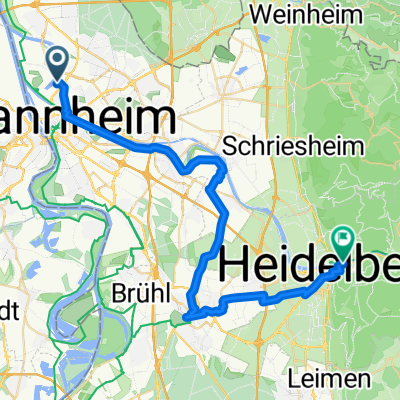
Wasserturm - Seckenheim
A cycling route starting in Mannheim, Baden-Wurttemberg, Germany.
Overview
About this route
Beautiful route, lots of nature, but not suitable during high water on the Neckar.
- -:--
- Duration
- 21.3 km
- Distance
- 57 m
- Ascent
- 51 m
- Descent
- ---
- Avg. speed
- ---
- Max. altitude
Route highlights
Points of interest along the route

Point of interest after 3.5 km
Feudenheimer Schleuse
Continue with Bikemap
Use, edit, or download this cycling route
You would like to ride Wasserturm - Seckenheim or customize it for your own trip? Here is what you can do with this Bikemap route:
Free features
- Save this route as favorite or in collections
- Copy & plan your own version of this route
- Sync your route with Garmin or Wahoo
Premium features
Free trial for 3 days, or one-time payment. More about Bikemap Premium.
- Navigate this route on iOS & Android
- Export a GPX / KML file of this route
- Create your custom printout (try it for free)
- Download this route for offline navigation
Discover more Premium features.
Get Bikemap PremiumFrom our community
Other popular routes starting in Mannheim
 Trainingsrunde
- Distance
- 69.5 km
- Ascent
- 630 m
- Descent
- 619 m
- Location
- Mannheim, Baden-Wurttemberg, Germany
 Apfelbaumtour 2
- Distance
- 70.6 km
- Ascent
- 1,077 m
- Descent
- 1,081 m
- Location
- Mannheim, Baden-Wurttemberg, Germany
 26.08.08
- Distance
- 109.2 km
- Ascent
- 1,659 m
- Descent
- 1,518 m
- Location
- Mannheim, Baden-Wurttemberg, Germany
 Von Mannheim bis Heidelberg
- Distance
- 37.9 km
- Ascent
- 85 m
- Descent
- 63 m
- Location
- Mannheim, Baden-Wurttemberg, Germany
 Feierabendrunde
- Distance
- 37.5 km
- Ascent
- 45 m
- Descent
- 45 m
- Location
- Mannheim, Baden-Wurttemberg, Germany
 Die Hausrunde XL (Rundweg um Mannheim)
- Distance
- 48.9 km
- Ascent
- 47 m
- Descent
- 47 m
- Location
- Mannheim, Baden-Wurttemberg, Germany
 Mannheim-Weinheim-Heidelberg-Schwetzingen-Mannheim
- Distance
- 105.3 km
- Ascent
- 875 m
- Descent
- 870 m
- Location
- Mannheim, Baden-Wurttemberg, Germany
 Mannheim Abendrunde
- Distance
- 50.9 km
- Ascent
- 477 m
- Descent
- 472 m
- Location
- Mannheim, Baden-Wurttemberg, Germany
Open it in the app