

Loures-Belém
A cycling route starting in Loures, Lisbon District, Portugal.
Overview
About this route
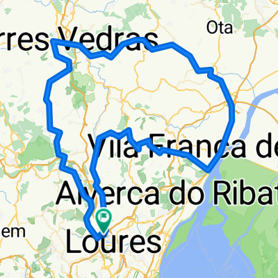
From Loures to Belém, through the hills til the coast of Tejo, go toward Lisbon, till Belém.
- -:--
- Duration
- 40.8 km
- Distance
- 335 m
- Ascent
- 347 m
- Descent
- ---
- Avg. speed
- ---
- Max. altitude

Continue with Bikemap
Use, edit, or download this cycling route
You would like to ride Loures-Belém or customize it for your own trip? Here is what you can do with this Bikemap route:
Free features
- Save this route as favorite or in collections
- Copy & plan your own version of this route
- Sync your route with Garmin or Wahoo
Premium features
Free trial for 3 days, or one-time payment. More about Bikemap Premium.
- Navigate this route on iOS & Android
- Export a GPX / KML file of this route
- Create your custom printout (try it for free)
- Download this route for offline navigation
Discover more Premium features.
Get Bikemap PremiumFrom our community
Other popular routes starting in Loures
 loucura
- Distance
- 221.3 km
- Ascent
- 821 m
- Descent
- 822 m
- Location
- Loures, Lisbon District, Portugal
 5mar17
- Distance
- 18 km
- Ascent
- 243 m
- Descent
- 242 m
- Location
- Loures, Lisbon District, Portugal
 Loures, PSA, Loures
- Distance
- 28.6 km
- Ascent
- 374 m
- Descent
- 372 m
- Location
- Loures, Lisbon District, Portugal
 Loures-Malveira-Torres Vedras-Alenquer-Alhandra-Arruda-Póvoa da Galega-Loures(130Km)
- Distance
- 128.7 km
- Ascent
- 995 m
- Descent
- 995 m
- Location
- Loures, Lisbon District, Portugal
 ride from 3 de dezembro, 08:29
- Distance
- 17.4 km
- Ascent
- 233 m
- Descent
- 233 m
- Location
- Loures, Lisbon District, Portugal
 CASA-PASTEL DE NATA
- Distance
- 29.7 km
- Ascent
- 143 m
- Descent
- 237 m
- Location
- Loures, Lisbon District, Portugal
 Baloiço (Estrada)
- Distance
- 13.6 km
- Ascent
- 364 m
- Descent
- 367 m
- Location
- Loures, Lisbon District, Portugal
 bike tour through loures
- Distance
- 16 km
- Ascent
- 192 m
- Descent
- 193 m
- Location
- Loures, Lisbon District, Portugal
Open it in the app