

Alpentocht 2015 dag 2 Definitief
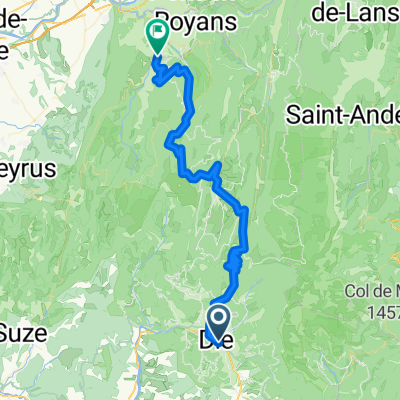
A cycling route starting in Die, Auvergne-Rhône-Alpes, France.
Overview
About this route
Pontaix - Lans-en-Vercors
- -:--
- Duration
- 97 km
- Distance
- 2,122 m
- Ascent
- 1,224 m
- Descent
- ---
- Avg. speed
- ---
- Max. altitude
Route highlights
Points of interest along the route

Point of interest after 63.4 km
Herbouilly
Continue with Bikemap
Use, edit, or download this cycling route
You would like to ride Alpentocht 2015 dag 2 Definitief or customize it for your own trip? Here is what you can do with this Bikemap route:
Free features
- Save this route as favorite or in collections
- Copy & plan your own version of this route
- Split it into stages to create a multi-day tour
- Sync your route with Garmin or Wahoo
Premium features
Free trial for 3 days, or one-time payment. More about Bikemap Premium.
- Navigate this route on iOS & Android
- Export a GPX / KML file of this route
- Create your custom printout (try it for free)
- Download this route for offline navigation
Discover more Premium features.
Get Bikemap PremiumFrom our community
Other popular routes starting in Die
 Die - Circle to St-Julien-en-Quint
- Distance
- 38.3 km
- Ascent
- 556 m
- Descent
- 553 m
- Location
- Die, Auvergne-Rhône-Alpes, France
 Die to Montrond
- Distance
- 66.8 km
- Ascent
- 1,363 m
- Descent
- 1,152 m
- Location
- Die, Auvergne-Rhône-Alpes, France
 Die - La Mure + La Mure - Grenoble
- Distance
- 206.7 km
- Ascent
- 5,077 m
- Descent
- 5,302 m
- Location
- Die, Auvergne-Rhône-Alpes, France
 2016 Ride Day 89 - Jansac to Valence
- Distance
- 90.1 km
- Ascent
- 177 m
- Descent
- 702 m
- Location
- Die, Auvergne-Rhône-Alpes, France
 FA13 Die St. Jean en Royans
- Distance
- 61.8 km
- Ascent
- 1,263 m
- Descent
- 1,423 m
- Location
- Die, Auvergne-Rhône-Alpes, France
 Tour du Glandasse
- Distance
- 32.6 km
- Ascent
- 929 m
- Descent
- 933 m
- Location
- Die, Auvergne-Rhône-Alpes, France
 Alpentocht 2015 dag 2: Pennes-le-Sec - Grenoble
- Distance
- 105.3 km
- Ascent
- 2,211 m
- Descent
- 1,356 m
- Location
- Die, Auvergne-Rhône-Alpes, France
 Ouest de Die
- Distance
- 83.5 km
- Ascent
- 858 m
- Descent
- 859 m
- Location
- Die, Auvergne-Rhône-Alpes, France
Open it in the app