
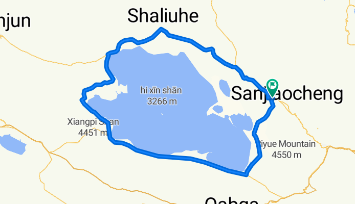
青海湖骑行图
A cycling route starting in Sanjiaocheng, Qinghai, China.
Overview
About this route
- -:--
- Duration
- 347.8 km
- Distance
- 787 m
- Ascent
- 790 m
- Descent
- ---
- Avg. speed
- ---
- Avg. speed

Continue with Bikemap
Use, edit, or download this cycling route
You would like to ride 青海湖骑行图 or customize it for your own trip? Here is what you can do with this Bikemap route:
Free features
- Save this route as favorite or in collections
- Copy & plan your own version of this route
- Sync your route with Garmin or Wahoo
Premium features
Free trial for 3 days, or one-time payment. More about Bikemap Premium.
- Navigate this route on iOS & Android
- Export a GPX / KML file of this route
- Create your custom printout (try it for free)
- Download this route for offline navigation
Discover more Premium features.
Get Bikemap PremiumFrom our community
Other popular routes starting in Sanjiaocheng
 环青海湖骑行路线
- Distance
- 349.6 km
- Ascent
- 793 m
- Descent
- 796 m
- Location
- Sanjiaocheng, Qinghai, China
 Tour of Qinghai Lake
- Distance
- 388.7 km
- Ascent
- 776 m
- Descent
- 775 m
- Location
- Sanjiaocheng, Qinghai, China
 IA Gold Qinghai Lake (50-70 km per day)
- Distance
- 246.5 km
- Ascent
- 1,855 m
- Descent
- 1,668 m
- Location
- Sanjiaocheng, Qinghai, China
![2011.06.06 - Tour of Qinghai lake [Stage 05]](https://media.bikemap.net/routes/1090245/staticmaps/in_a8290ca9-fe87-4541-a5a9-69ca50aff15b_400x400_bikemap-2021-3D-static.png) 2011.06.06 - Tour of Qinghai lake [Stage 05]
2011.06.06 - Tour of Qinghai lake [Stage 05]- Distance
- 122.4 km
- Ascent
- 1,007 m
- Descent
- 693 m
- Location
- Sanjiaocheng, Qinghai, China
 青海湖环湖线
- Distance
- 372.6 km
- Ascent
- 610 m
- Descent
- 611 m
- Location
- Sanjiaocheng, Qinghai, China
 青海湖骑行图
- Distance
- 347.8 km
- Ascent
- 787 m
- Descent
- 790 m
- Location
- Sanjiaocheng, Qinghai, China
 海晏-环湖东路
- Distance
- 19.3 km
- Ascent
- 317 m
- Descent
- 124 m
- Location
- Sanjiaocheng, Qinghai, China
 环青海湖骑行
- Distance
- 380 km
- Ascent
- 661 m
- Descent
- 660 m
- Location
- Sanjiaocheng, Qinghai, China
Open it in the app