

Alpen 2015 - Dag 5
A cycling route starting in Châtillon, Auvergne-Rhône-Alpes, France.
Overview
About this route
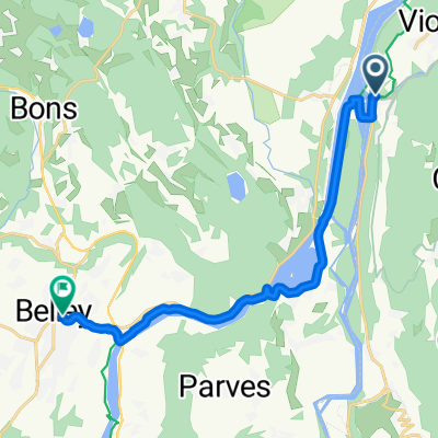
Chanaz - Annecy
- -:--
- Duration
- 95.9 km
- Distance
- 2,079 m
- Ascent
- 1,865 m
- Descent
- ---
- Avg. speed
- ---
- Max. altitude
Route quality
Waytypes & surfaces along the route
Waytypes
Road
37.4 km
(39 %)
Quiet road
12.5 km
(13 %)
Surfaces
Paved
58.5 km
(61 %)
Unpaved
1 km
(1 %)
Asphalt
58.5 km
(61 %)
Gravel
1 km
(1 %)
Undefined
36.4 km
(38 %)
Route highlights
Points of interest along the route

Point of interest after 17.5 km
Col du Sapenaey

Point of interest after 63.8 km
Crête du Chatillon
Continue with Bikemap
Use, edit, or download this cycling route
You would like to ride Alpen 2015 - Dag 5 or customize it for your own trip? Here is what you can do with this Bikemap route:
Free features
- Save this route as favorite or in collections
- Copy & plan your own version of this route
- Split it into stages to create a multi-day tour
- Sync your route with Garmin or Wahoo
Premium features
Free trial for 3 days, or one-time payment. More about Bikemap Premium.
- Navigate this route on iOS & Android
- Export a GPX / KML file of this route
- Create your custom printout (try it for free)
- Download this route for offline navigation
Discover more Premium features.
Get Bikemap PremiumFrom our community
Other popular routes starting in Châtillon
 Tag 4 Mont Ventoux
- Distance
- 103 km
- Ascent
- 586 m
- Descent
- 541 m
- Location
- Châtillon, Auvergne-Rhône-Alpes, France
 2014.07.06 Via Rhona
- Distance
- 69.2 km
- Ascent
- 170 m
- Descent
- 131 m
- Location
- Châtillon, Auvergne-Rhône-Alpes, France
 EuroVelo17-02-Chanaz-Lyon
- Distance
- 129.7 km
- Ascent
- 614 m
- Descent
- 683 m
- Location
- Châtillon, Auvergne-Rhône-Alpes, France
 chanazJongieuChanaz
- Distance
- 37.5 km
- Ascent
- 1,135 m
- Descent
- 1,143 m
- Location
- Châtillon, Auvergne-Rhône-Alpes, France
 Chanaz Ontex
- Distance
- 35.5 km
- Ascent
- 1,192 m
- Descent
- 1,176 m
- Location
- Châtillon, Auvergne-Rhône-Alpes, France
 De Conjux à Vions - Chanaz
- Distance
- 13 km
- Ascent
- 51 m
- Descent
- 45 m
- Location
- Châtillon, Auvergne-Rhône-Alpes, France
 Dag2 laatse deel
- Distance
- 14.2 km
- Ascent
- 85 m
- Descent
- 43 m
- Location
- Châtillon, Auvergne-Rhône-Alpes, France
 Etape 3 (58km) - Camping de Chanaz à celui de Morestel
- Distance
- 58.4 km
- Ascent
- 263 m
- Descent
- 284 m
- Location
- Châtillon, Auvergne-Rhône-Alpes, France
Open it in the app