

15vga
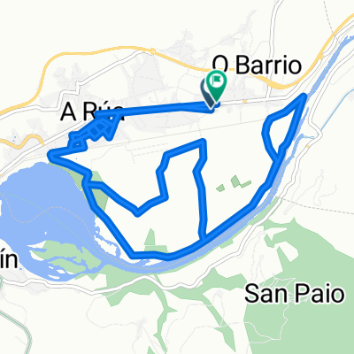
A cycling route starting in A Rúa, Galicia, Spain.
Overview
About this route
ffsfsf
- -:--
- Duration
- 192.6 km
- Distance
- 2,721 m
- Ascent
- 2,392 m
- Descent
- ---
- Avg. speed
- ---
- Max. altitude
Route quality
Waytypes & surfaces along the route
Waytypes
Road
96.3 km
(50 %)
Quiet road
38.5 km
(20 %)
Surfaces
Paved
38.5 km
(20 %)
Unpaved
1.9 km
(1 %)
Asphalt
38.5 km
(20 %)
Gravel
1.9 km
(1 %)
Undefined
152.1 km
(79 %)
Continue with Bikemap
Use, edit, or download this cycling route
You would like to ride 15vga or customize it for your own trip? Here is what you can do with this Bikemap route:
Free features
- Save this route as favorite or in collections
- Copy & plan your own version of this route
- Split it into stages to create a multi-day tour
- Sync your route with Garmin or Wahoo
Premium features
Free trial for 3 days, or one-time payment. More about Bikemap Premium.
- Navigate this route on iOS & Android
- Export a GPX / KML file of this route
- Create your custom printout (try it for free)
- Download this route for offline navigation
Discover more Premium features.
Get Bikemap PremiumFrom our community
Other popular routes starting in A Rúa
 7ª Etapa Ibérica 2015
- Distance
- 199.9 km
- Ascent
- 1,211 m
- Descent
- 1,488 m
- Location
- A Rúa, Galicia, Spain
 Mañana Jueves 31 Julio
- Distance
- 14.9 km
- Ascent
- 167 m
- Descent
- 227 m
- Location
- A Rúa, Galicia, Spain
 15vga
15vga- Distance
- 192.6 km
- Ascent
- 2,721 m
- Descent
- 2,392 m
- Location
- A Rúa, Galicia, Spain
 PedrasBlancas-SanXulian
- Distance
- 17.9 km
- Ascent
- 755 m
- Descent
- 798 m
- Location
- A Rúa, Galicia, Spain
 Rúa-SanMiguel-Vilamartin-Petin-Rúa
- Distance
- 17.2 km
- Ascent
- 173 m
- Descent
- 213 m
- Location
- A Rúa, Galicia, Spain
 Camino de Invierno - Tramo Gallego - Primera Etapa: A Rúa - Chantada
- Distance
- 96.7 km
- Ascent
- 1,634 m
- Descent
- 1,433 m
- Location
- A Rúa, Galicia, Spain
 VILLAMARIN - SADA
- Distance
- 201.7 km
- Ascent
- 1,190 m
- Descent
- 1,490 m
- Location
- A Rúa, Galicia, Spain
 De Rúa Otero Pedrayo 2, Vilamartín de Valdeorras a Avenida Eulogio Fernández 73, El Barco de Valdeorras
- Distance
- 6.8 km
- Ascent
- 96 m
- Descent
- 80 m
- Location
- A Rúa, Galicia, Spain
Open it in the app