

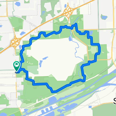
TImberline ascent in Lemont
A cycling route starting in Lemont, Illinois, United States of America.
Overview
About this route
590 feet to 750 feet climb (160 feet or 50 m)
- -:--
- Duration
- 1.7 km
- Distance
- 48 m
- Ascent
- 0 m
- Descent
- ---
- Avg. speed
- 231 m
- Max. altitude

Route quality
Waytypes & surfaces along the route
Waytypes
Road
1.7 km
(100 %)
Continue with Bikemap
Use, edit, or download this cycling route
You would like to ride TImberline ascent in Lemont or customize it for your own trip? Here is what you can do with this Bikemap route:
Free features
- Save this route as favorite or in collections
- Copy & plan your own version of this route
- Sync your route with Garmin or Wahoo
Premium features
Free trial for 3 days, or one-time payment. More about Bikemap Premium.
- Navigate this route on iOS & Android
- Export a GPX / KML file of this route
- Create your custom printout (try it for free)
- Download this route for offline navigation
Discover more Premium features.
Get Bikemap PremiumFrom our community
Other popular routes starting in Lemont
 136 Erin Ct, Lemont to 307–397 S Spencer Rd, New Lenox
- Distance
- 23 km
- Ascent
- 118 m
- Descent
- 125 m
- Location
- Lemont, Illinois, United States of America
 cal sag bike path
- Distance
- 35.8 km
- Ascent
- 13 m
- Descent
- 9 m
- Location
- Lemont, Illinois, United States of America
 TImberline ascent in Lemont
- Distance
- 1.7 km
- Ascent
- 48 m
- Descent
- 0 m
- Location
- Lemont, Illinois, United States of America
 Lemont Rd, Woodridge to Lemont Rd, Woodridge
- Distance
- 15.7 km
- Ascent
- 117 m
- Descent
- 117 m
- Location
- Lemont, Illinois, United States of America
 Waterfall Glen back to Cal Sag
- Distance
- 25.9 km
- Ascent
- 31 m
- Descent
- 84 m
- Location
- Lemont, Illinois, United States of America
 Lemont to Waterfall Glen Fp, Lemont
- Distance
- 5.3 km
- Ascent
- 91 m
- Descent
- 88 m
- Location
- Lemont, Illinois, United States of America
 Old Archer Ave, Lemont to Old Archer Ave, Lemont
- Distance
- 22.4 km
- Ascent
- 120 m
- Descent
- 120 m
- Location
- Lemont, Illinois, United States of America
 Lemont Road 1570 to Lemont Road 1570
- Distance
- 15.8 km
- Ascent
- 112 m
- Descent
- 108 m
- Location
- Lemont, Illinois, United States of America
Open it in the app