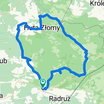
VVRoztocze5
A cycling route starting in Horyniec-Zdr贸j, Subcarpathian Voivodeship, Poland.
Overview
About this route
Horyniec - Borowe M艂yny - G贸recko Ko艣cielne
- -:--
- Duration
- 65.4 km
- Distance
- 165 m
- Ascent
- 176 m
- Descent
- ---
- Avg. speed
- ---
- Max. altitude
Route quality
Waytypes & surfaces along the route
Waytypes
Road
19.6 km
(30 %)
Access road
15.7 km
(24 %)
Surfaces
Paved
47.7 km
(73 %)
Unpaved
12.4 km
(19 %)
Asphalt
47.1 km
(72 %)
Gravel
6.5 km
(10 %)
Continue with Bikemap
Use, edit, or download this cycling route
You would like to ride VVRoztocze5 or customize it for your own trip? Here is what you can do with this Bikemap route:
Free features
- Save this route as favorite or in collections
- Copy & plan your own version of this route
- Sync your route with Garmin or Wahoo
Premium features
Free trial for 3 days, or one-time payment. More about Bikemap Premium.
- Navigate this route on iOS & Android
- Export a GPX / KML file of this route
- Create your custom printout (try it for free)
- Download this route for offline navigation
Discover more Premium features.
Get Bikemap PremiumFrom our community
Other popular routes starting in Horyniec-Zdr贸j
Horyniec-Green Velo-Basznia Dolna-57 km- Distance
- 56.5 km
- Ascent
- 344 m
- Descent
- 345 m
- Location
- Horyniec-Zdr贸j, Subcarpathian Voivodeship, Poland
Horyniec-Ruda Rozanecka-28 km- Distance
- 27.4 km
- Ascent
- 166 m
- Descent
- 185 m
- Location
- Horyniec-Zdr贸j, Subcarpathian Voivodeship, Poland
Roztocze6- Distance
- 62.1 km
- Ascent
- 317 m
- Descent
- 346 m
- Location
- Horyniec-Zdr贸j, Subcarpathian Voivodeship, Poland
Szumy Tanwii- Distance
- 74.2 km
- Ascent
- 340 m
- Descent
- 344 m
- Location
- Horyniec-Zdr贸j, Subcarpathian Voivodeship, Poland
Roztocze Po艂udniowe- Distance
- 15.4 km
- Ascent
- 165 m
- Descent
- 159 m
- Location
- Horyniec-Zdr贸j, Subcarpathian Voivodeship, Poland
Roztocze5-p臋tla- Distance
- 68.7 km
- Ascent
- 272 m
- Descent
- 275 m
- Location
- Horyniec-Zdr贸j, Subcarpathian Voivodeship, Poland
Horyniec - Radawa przez 艣cie偶ki rowerowe le艣ne.- Distance
- 58 km
- Ascent
- 245 m
- Descent
- 307 m
- Location
- Horyniec-Zdr贸j, Subcarpathian Voivodeship, Poland
VVRoztocze5- Distance
- 65.4 km
- Ascent
- 165 m
- Descent
- 176 m
- Location
- Horyniec-Zdr贸j, Subcarpathian Voivodeship, Poland
Open it in the app


