

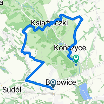
Raciborowice - Michałowice
A cycling route starting in Michałowice, Lesser Poland Voivodeship, Poland.
Overview
About this route
<span style="color: rgb(74, 74, 74); font-family: sans-serif; font-size: 14px; line-height: 21px;"><font><font>Szlak o dużych walorach krajobrazowych prowadzący na szeregu odcinkach niezabudowanymi jeszcze terenami przez wschodnie rejony gminy Zielonki, głównie drogami asfaltowymi o minimalnym natężeniu ruchu oraz drogami utwardzonymi. </font><font>Szlak jest średniej trudności biorąc pod uwagę podjazdy pod Pomnik w Bosutowie, z Doliny Dłubni do Dziekanowic, także wyjazd z. Wąwozu Kamieniec.</font></font></span>
(cloned from route 2733926)
- -:--
- Duration
- 13.3 km
- Distance
- 190 m
- Ascent
- 180 m
- Descent
- ---
- Avg. speed
- ---
- Max. altitude
Route quality
Waytypes & surfaces along the route
Waytypes
Quiet road
8.5 km
(64 %)
Road
2.7 km
(20 %)
Surfaces
Paved
10.2 km
(77 %)
Unpaved
2.7 km
(20 %)
Asphalt
10.2 km
(77 %)
Gravel
1.6 km
(12 %)
Route highlights
Points of interest along the route

Point of interest after 4.1 km
Zespół dworski w Boleniu
Continue with Bikemap
Use, edit, or download this cycling route
You would like to ride Raciborowice - Michałowice or customize it for your own trip? Here is what you can do with this Bikemap route:
Free features
- Save this route as favorite or in collections
- Copy & plan your own version of this route
- Sync your route with Garmin or Wahoo
Premium features
Free trial for 3 days, or one-time payment. More about Bikemap Premium.
- Navigate this route on iOS & Android
- Export a GPX / KML file of this route
- Create your custom printout (try it for free)
- Download this route for offline navigation
Discover more Premium features.
Get Bikemap PremiumFrom our community
Other popular routes starting in Michałowice
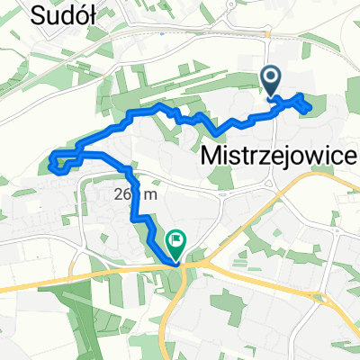 mistrzejowice-25
- Distance
- 6 km
- Ascent
- 75 m
- Descent
- 87 m
- Location
- Michałowice, Lesser Poland Voivodeship, Poland
 Recording from 29 sierpnia, 10:02
- Distance
- 42.3 km
- Ascent
- 351 m
- Descent
- 350 m
- Location
- Michałowice, Lesser Poland Voivodeship, Poland
 KRK: NH -> Ojców -> Będkowska -> Kleszczów -> Mydlniki -> NH
- Distance
- 81.8 km
- Ascent
- 548 m
- Descent
- 548 m
- Location
- Michałowice, Lesser Poland Voivodeship, Poland
 Mistrzejowice-bibice-zielonki-bronowice
- Distance
- 42.2 km
- Ascent
- 229 m
- Descent
- 228 m
- Location
- Michałowice, Lesser Poland Voivodeship, Poland
 Nowa trasa 01.10
- Distance
- 4.5 km
- Ascent
- 87 m
- Descent
- 46 m
- Location
- Michałowice, Lesser Poland Voivodeship, Poland
 Zielona trasa rowerowa
- Distance
- 22.5 km
- Ascent
- 269 m
- Descent
- 269 m
- Location
- Michałowice, Lesser Poland Voivodeship, Poland
 Trasa 04.10
- Distance
- 11.7 km
- Ascent
- 159 m
- Descent
- 180 m
- Location
- Michałowice, Lesser Poland Voivodeship, Poland
 Raciborowice - Michałowice
- Distance
- 13.3 km
- Ascent
- 190 m
- Descent
- 180 m
- Location
- Michałowice, Lesser Poland Voivodeship, Poland
Open it in the app