

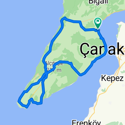
Gelibolu Yarımadası Genel Tur
A cycling route starting in Eceabat, Çanakkale Province, Turkey.
Overview
About this route
Max:153m Tırmanış
- -:--
- Duration
- 64.9 km
- Distance
- 474 m
- Ascent
- 474 m
- Descent
- ---
- Avg. speed
- ---
- Max. altitude
Route quality
Waytypes & surfaces along the route
Waytypes
Busy road
39.7 km
(61 %)
Road
22.6 km
(35 %)
Surfaces
Paved
24.1 km
(37 %)
Unpaved
4 km
(6 %)
Asphalt
24.1 km
(37 %)
Gravel
4 km
(6 %)
Undefined
36.8 km
(57 %)
Route highlights
Points of interest along the route
Point of interest after 16.3 km
Su Molası
Point of interest after 23.6 km
Su Molası
Continue with Bikemap
Use, edit, or download this cycling route
You would like to ride Gelibolu Yarımadası Genel Tur or customize it for your own trip? Here is what you can do with this Bikemap route:
Free features
- Save this route as favorite or in collections
- Copy & plan your own version of this route
- Sync your route with Garmin or Wahoo
Premium features
Free trial for 3 days, or one-time payment. More about Bikemap Premium.
- Navigate this route on iOS & Android
- Export a GPX / KML file of this route
- Create your custom printout (try it for free)
- Download this route for offline navigation
Discover more Premium features.
Get Bikemap PremiumFrom our community
Other popular routes starting in Eceabat
 Gelibolu Yarımadası Genel Tur
- Distance
- 64.9 km
- Ascent
- 474 m
- Descent
- 474 m
- Location
- Eceabat, Çanakkale Province, Turkey
 Gelibolu köyleri
- Distance
- 73.5 km
- Ascent
- 496 m
- Descent
- 496 m
- Location
- Eceabat, Çanakkale Province, Turkey
 gökçeada tur planı
- Distance
- 130.9 km
- Ascent
- 882 m
- Descent
- 888 m
- Location
- Eceabat, Çanakkale Province, Turkey
 GELİBOLU TRİATHLON RUN COURSE
- Distance
- 21 km
- Ascent
- 112 m
- Descent
- 114 m
- Location
- Eceabat, Çanakkale Province, Turkey
 Bigalı Kalesi-Jandarma Şehitliği
- Distance
- 40.7 km
- Ascent
- 241 m
- Descent
- 203 m
- Location
- Eceabat, Çanakkale Province, Turkey
 havuzlar
- Distance
- 3.7 km
- Ascent
- 13 m
- Descent
- 84 m
- Location
- Eceabat, Çanakkale Province, Turkey
 gökçeada-bandırma-yenikapı
- Distance
- 183.8 km
- Ascent
- 789 m
- Descent
- 798 m
- Location
- Eceabat, Çanakkale Province, Turkey
 CANAKKALE
- Distance
- 98.3 km
- Ascent
- 719 m
- Descent
- 716 m
- Location
- Eceabat, Çanakkale Province, Turkey
Open it in the app