
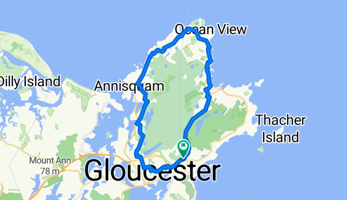
23mi Long route Rockport
A cycling route starting in Gloucester, Massachusetts, United States.
Overview
About this route
Long route
- -:--
- Duration
- 22.9 km
- Distance
- 242 m
- Ascent
- 242 m
- Descent
- ---
- Avg. speed
- ---
- Max. altitude
Route quality
Waytypes & surfaces along the route
Waytypes
Quiet road
12.1 km
(53 %)
Access road
0.5 km
(2 %)
Surfaces
Paved
5 km
(22 %)
Asphalt
5 km
(22 %)
Undefined
17.8 km
(78 %)
Continue with Bikemap
Use, edit, or download this cycling route
You would like to ride 23mi Long route Rockport or customize it for your own trip? Here is what you can do with this Bikemap route:
Free features
- Save this route as favorite or in collections
- Copy & plan your own version of this route
- Sync your route with Garmin or Wahoo
Premium features
Free trial for 3 days, or one-time payment. More about Bikemap Premium.
- Navigate this route on iOS & Android
- Export a GPX / KML file of this route
- Create your custom printout (try it for free)
- Download this route for offline navigation
Discover more Premium features.
Get Bikemap PremiumFrom our community
Other popular routes starting in Gloucester
 Untitled route
- Distance
- 264.1 km
- Ascent
- 2,677 m
- Descent
- 2,634 m
- Location
- Gloucester, Massachusetts, United States
 32 Leslie O Johnson Rd, Gloucester to 32 Leslie O Johnson Rd, Gloucester
- Distance
- 20.1 km
- Ascent
- 150 m
- Descent
- 150 m
- Location
- Gloucester, Massachusetts, United States
 Easy ride in Gloucester
- Distance
- 0.2 km
- Ascent
- 3 m
- Descent
- 0 m
- Location
- Gloucester, Massachusetts, United States
 2010-05-10 - Massachussett - Cape Ann CLONED FROM ROUTE 494523
- Distance
- 39.3 km
- Ascent
- 157 m
- Descent
- 155 m
- Location
- Gloucester, Massachusetts, United States
 27–37 State Fish Pier, Gloucester to 99 Thatcher Rd, Gloucester
- Distance
- 16.1 km
- Ascent
- 4 m
- Descent
- 12 m
- Location
- Gloucester, Massachusetts, United States
 The Island
- Distance
- 31.3 km
- Ascent
- 196 m
- Descent
- 200 m
- Location
- Gloucester, Massachusetts, United States
 Best Buddies Virtual Challenge: Cape Ann
- Distance
- 14.1 km
- Ascent
- 107 m
- Descent
- 108 m
- Location
- Gloucester, Massachusetts, United States
 76 Atlantic St, Gloucester to 2–98 18th St, Newbury
- Distance
- 51 km
- Ascent
- 361 m
- Descent
- 364 m
- Location
- Gloucester, Massachusetts, United States
Open it in the app