

150621 Sonntagstour
A cycling route starting in Altensteig, Baden-Württemberg, Germany.
Overview
About this route
Vorbereitung MOA
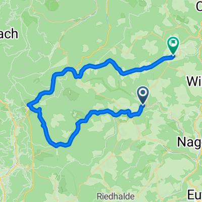
mit demAut nach Berneck Altenstei Erzgrube Schorrenwald Besenfeld Simmersfeld über Zwerenerg nach Neubulach- -:--
- Duration
- 49.8 km
- Distance
- 489 m
- Ascent
- 357 m
- Descent
- ---
- Avg. speed
- ---
- Max. altitude
Route quality
Waytypes & surfaces along the route
Waytypes
Road
21.6 km
(43 %)
Busy road
20.4 km
(41 %)
Surfaces
Paved
39.4 km
(79 %)
Unpaved
1 km
(2 %)
Asphalt
38.5 km
(77 %)
Gravel
1 km
(2 %)
Continue with Bikemap
Use, edit, or download this cycling route
You would like to ride 150621 Sonntagstour or customize it for your own trip? Here is what you can do with this Bikemap route:
Free features
- Save this route as favorite or in collections
- Copy & plan your own version of this route
- Sync your route with Garmin or Wahoo
Premium features
Free trial for 3 days, or one-time payment. More about Bikemap Premium.
- Navigate this route on iOS & Android
- Export a GPX / KML file of this route
- Create your custom printout (try it for free)
- Download this route for offline navigation
Discover more Premium features.
Get Bikemap PremiumFrom our community
Other popular routes starting in Altensteig
 camping swartswald 33 km
- Distance
- 32.8 km
- Ascent
- 617 m
- Descent
- 608 m
- Location
- Altensteig, Baden-Württemberg, Germany
 some nice hills :)
- Distance
- 66.8 km
- Ascent
- 852 m
- Descent
- 852 m
- Location
- Altensteig, Baden-Württemberg, Germany
 150621 Sonntagstour
- Distance
- 49.8 km
- Ascent
- 489 m
- Descent
- 357 m
- Location
- Altensteig, Baden-Württemberg, Germany
 Hochdorf
- Distance
- 60 km
- Ascent
- 654 m
- Descent
- 469 m
- Location
- Altensteig, Baden-Württemberg, Germany
 2019 Tag2 Besenfeld - Herrenberg
- Distance
- 29.6 km
- Ascent
- 320 m
- Descent
- 350 m
- Location
- Altensteig, Baden-Württemberg, Germany
 Von Überberg nach Berneck
- Distance
- 12 km
- Ascent
- 231 m
- Descent
- 239 m
- Location
- Altensteig, Baden-Württemberg, Germany
 Leichte Familientour um Altensteig
- Distance
- 22.4 km
- Ascent
- 453 m
- Descent
- 440 m
- Location
- Altensteig, Baden-Württemberg, Germany
 Zinsbachtal
- Distance
- 27.6 km
- Ascent
- 351 m
- Descent
- 343 m
- Location
- Altensteig, Baden-Württemberg, Germany
Open it in the app