
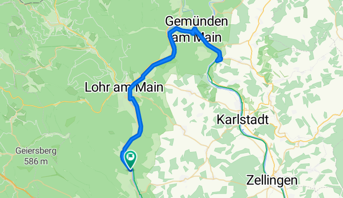
Rothenfels - Wernfeld - Rothenfels
A cycling route starting in Rothenfels, Bavaria, Germany.
Overview
About this route
Čtvrtá část cesty podél Mohanu. Všechny trasy jsou ideální pro rodiny s dětmi. Začátky tras jsou u kempů, které jsou velmi dobře vybaveny.
Další trasy vedou z Bad Staffelsteinu, Volkachu a Freudenbergu.
Příjemná cesta podél vody po cyklostezce.
- -:--
- Duration
- 61.6 km
- Distance
- 379 m
- Ascent
- 391 m
- Descent
- ---
- Avg. speed
- 230 m
- Max. altitude
Route quality
Waytypes & surfaces along the route
Waytypes
Cycleway
30.4 km
(49 %)
Path
16.4 km
(27 %)
Surfaces
Paved
59.3 km
(96 %)
Unpaved
0.4 km
(<1 %)
Asphalt
54.4 km
(88 %)
Paved (undefined)
2.2 km
(4 %)
Continue with Bikemap
Use, edit, or download this cycling route
You would like to ride Rothenfels - Wernfeld - Rothenfels or customize it for your own trip? Here is what you can do with this Bikemap route:
Free features
- Save this route as favorite or in collections
- Copy & plan your own version of this route
- Sync your route with Garmin or Wahoo
Premium features
Free trial for 3 days, or one-time payment. More about Bikemap Premium.
- Navigate this route on iOS & Android
- Export a GPX / KML file of this route
- Create your custom printout (try it for free)
- Download this route for offline navigation
Discover more Premium features.
Get Bikemap PremiumFrom our community
Other popular routes starting in Rothenfels
 Hafenlohrtal - Karlshöhe - Lichtenau - Aurora CLONED FROM ROUTE 204691
- Distance
- 30 km
- Ascent
- 867 m
- Descent
- 867 m
- Location
- Rothenfels, Bavaria, Germany
 Rothenfels - Wernfeld - Rothenfels
- Distance
- 61.6 km
- Ascent
- 379 m
- Descent
- 391 m
- Location
- Rothenfels, Bavaria, Germany
 Lohr-Marktheidenfeld
- Distance
- 37 km
- Ascent
- 133 m
- Descent
- 118 m
- Location
- Rothenfels, Bavaria, Germany
 Mainstraße 14, Rothenfels nach Mainstraße 15, Rothenfels
- Distance
- 18.2 km
- Ascent
- 82 m
- Descent
- 80 m
- Location
- Rothenfels, Bavaria, Germany
 Taubertal 3
- Distance
- 88.7 km
- Ascent
- 219 m
- Descent
- 149 m
- Location
- Rothenfels, Bavaria, Germany
 Rothenfels - Wertheim - Rothenfels
- Distance
- 63.1 km
- Ascent
- 163 m
- Descent
- 156 m
- Location
- Rothenfels, Bavaria, Germany
 St 2315, Rothenfels nach Lindenstraße 16A, Wertheim
- Distance
- 31.5 km
- Ascent
- 122 m
- Descent
- 133 m
- Location
- Rothenfels, Bavaria, Germany
 03 1.5.17
- Distance
- 105.9 km
- Ascent
- 168 m
- Descent
- 155 m
- Location
- Rothenfels, Bavaria, Germany
Open it in the app