

Leon Marshall Wall and Wilson Hill
A cycling route starting in Inverness, California, United States.
Overview
About this route
This is Leon Sun's ride
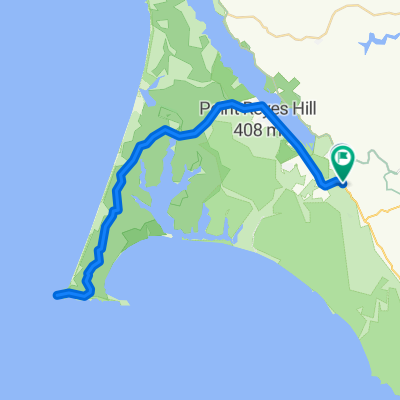
<span style="color: #000000; font-family: arial; font-size: 11px; line-height: 13px;">Will lead a ride on the 20th in <span id="lw_1252646841_0" class="yshortcuts" style="line-height: 1.2em; outline-style: none; outline-width: initial; outline-color: initial; cursor: pointer; background-image: initial; background-repeat: initial; background-attachment: initial; -webkit-background-clip: initial; -webkit-background-origin: initial; background-color: transparent; border-bottom-style: none; border-bottom-width: initial; border-bottom-color: initial; background-position: initial initial;">West Marin</span>. Toward the end of the ride, I want to stop at the G.R.O. Art Gallery in Pt Reyes Station where my friend Lucien Kubo has a solo show. Here are the details of the ride, if you don't mind posting it:<br style="line-height: 1.2em; outline-style: none; outline-width: initial; outline-color: initial;" /><br style="line-height: 1.2em; outline-style: none; outline-width: initial; outline-color: initial;" />Start: 9:00 a.m., <span id="lw_1252646841_1" class="yshortcuts" style="line-height: 1.2em; outline-style: none; outline-width: initial; outline-color: initial; border-bottom-style: dashed; border-bottom-width: 1px; border-bottom-color: #0066cc; cursor: pointer; background-image: initial; background-repeat: initial; background-attachment: initial; -webkit-background-clip: initial; -webkit-background-origin: initial; background-color: transparent; background-position: initial initial;">Bear Valley Visitor Center</span>, <span id="lw_1252646841_2" class="yshortcuts" style="line-height: 1.2em; outline-style: none; outline-width: initial; outline-color: initial; cursor: pointer; background-image: initial; background-repeat: initial; background-attachment: initial; -webkit-background-clip: initial; -webkit-background-origin: initial; background-color: transparent; border-bottom-style: none; border-bottom-width: initial; border-bottom-color: initial; background-position: initial initial;">Bear Valley Rd</span>, <span id="lw_1252646841_3" class="yshortcuts" style="line-height: 1.2em; outline-style: none; outline-width: initial; outline-color: initial; cursor: pointer; background-image: initial; background-repeat: initial; background-attachment: initial; -webkit-background-clip: initial; -webkit-background-origin: initial; background-color: transparent; border-bottom-style: none; border-bottom-width: initial; border-bottom-color: initial; background-position: initial initial;">Olema</span>. <br style="line-height: 1.2em; outline-style: none; outline-width: initial; outline-color: initial;" /><br style="line-height: 1.2em; outline-style: none; outline-width: initial; outline-color: initial;" />Route: Exiting Visitor Center, R onto Bear Valley Rd, L (North) onto Hwy 1, R onto Marshal-Petaluma Rd (Marshall Wall, about 1100' elev gain), L onto <span id="lw_1252646841_4" class="yshortcuts" style="line-height: 1.2em; outline-style: none; outline-width: initial; outline-color: initial;">Wilson Hill Rd</span>, L onto Chileno Valley Rd, L onto Tomales-Petaluma Rd, R onto Hwy 1 to <span id="lw_1252646841_5" class="yshortcuts" style="line-height: 1.2em; outline-style: none; outline-width: initial; outline-color: initial; cursor: pointer; background-image: initial; background-repeat: initial; background-attachment: initial; -webkit-background-clip: initial; -webkit-background-origin: initial; background-color: transparent; border-bottom-style: none; border-bottom-width: initial; border-bottom-color: initial; background-position: initial initial;">Tomales</span>, stop for lunch or snack, Return South on Hwy1 all the way to Bear Valley Rd, turn R, L into Visitor Center.<br style="line-height: 1.2em; outline-style: none; outline-width: initial; outline-color: initial;" /><br style="line-height: 1.2em; outline-style: none; outline-width: initial; outline-color: initial;" />Marshall Wall and Wilson Hill are the two major climbs, about 1500' el.gain combined. The rest are rollers. About 60 miles, total distance. Overlaps parts of Pilgrimage route. Stopping at gallery, of course, is optional.<br style="line-height: 1.2em; outline-style: none; outline-width: initial; outline-color: initial;" /></span>
- -:--
- Duration
- 98.3 km
- Distance
- 1,271 m
- Ascent
- 1,276 m
- Descent
- ---
- Avg. speed
- 220 m
- Max. altitude
Route quality
Waytypes & surfaces along the route
Waytypes
Road
20.6 km
(21 %)
Quiet road
1 km
(1 %)
Undefined
76.7 km
(78 %)
Surfaces
Paved
44.2 km
(45 %)
Asphalt
44.2 km
(45 %)
Undefined
54.1 km
(55 %)
Route highlights
Points of interest along the route
Point of interest after 20.3 km
R Marshall-Petaluma Rod (Marshall Wall about 1100' elev gain)
Point of interest after 42.4 km
L Chileno Valley Rd
Point of interest after 53.4 km
R Chileno Valley Rd
Point of interest after 58.1 km
L Tomales Petaluma Rd.
Point of interest after 67.1 km
Point of interest after 67.8 km
LUNCH IN TOMALES
Point of interest after 68.4 km
L Shoreline HWY1
Continue with Bikemap
Use, edit, or download this cycling route
You would like to ride Leon Marshall Wall and Wilson Hill or customize it for your own trip? Here is what you can do with this Bikemap route:
Free features
- Save this route as favorite or in collections
- Copy & plan your own version of this route
- Split it into stages to create a multi-day tour
- Sync your route with Garmin or Wahoo
Premium features
Free trial for 3 days, or one-time payment. More about Bikemap Premium.
- Navigate this route on iOS & Android
- Export a GPX / KML file of this route
- Create your custom printout (try it for free)
- Download this route for offline navigation
Discover more Premium features.
Get Bikemap PremiumFrom our community
Other popular routes starting in Inverness
 route 20
- Distance
- 43.7 km
- Ascent
- 344 m
- Descent
- 376 m
- Location
- Inverness, California, United States
 Point Reyes to Sf to Corte Madera
- Distance
- 77.9 km
- Ascent
- 1,537 m
- Descent
- 1,558 m
- Location
- Inverness, California, United States
 Johnston, Inverness to , Inverness
- Distance
- 23.5 km
- Ascent
- 388 m
- Descent
- 399 m
- Location
- Inverness, California, United States
 Point Reyes Out & Back
- Distance
- 96.8 km
- Ascent
- 729 m
- Descent
- 624 m
- Location
- Inverness, California, United States
 Pierce Point
- Distance
- 26.5 km
- Ascent
- 391 m
- Descent
- 350 m
- Location
- Inverness, California, United States
 Point Reyes N 2
- Distance
- 25.1 km
- Ascent
- 555 m
- Descent
- 562 m
- Location
- Inverness, California, United States
 Point Reyes, CA -USA
- Distance
- 64 km
- Ascent
- 572 m
- Descent
- 577 m
- Location
- Inverness, California, United States
 PointReyes-RussionRiver-Run
- Distance
- 147.8 km
- Ascent
- 618 m
- Descent
- 618 m
- Location
- Inverness, California, United States
Open it in the app