

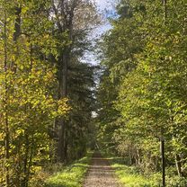
Ettlingen-mahlberg-wattkopf
A cycling route starting in Ettlingen, Baden-Wurttemberg, Germany.
Overview
About this route
tbd
(cloned from route 2682361)
- -:--
- Duration
- 48.4 km
- Distance
- 865 m
- Ascent
- 861 m
- Descent
- ---
- Avg. speed
- ---
- Max. altitude

Route quality
Waytypes & surfaces along the route
Waytypes
Track
37.3 km
(77 %)
Path
5.8 km
(12 %)
Surfaces
Paved
10.2 km
(21 %)
Unpaved
35.8 km
(74 %)
Gravel
19.9 km
(41 %)
Asphalt
8.7 km
(18 %)
Continue with Bikemap
Use, edit, or download this cycling route
You would like to ride Ettlingen-mahlberg-wattkopf or customize it for your own trip? Here is what you can do with this Bikemap route:
Free features
- Save this route as favorite or in collections
- Copy & plan your own version of this route
- Sync your route with Garmin or Wahoo
Premium features
Free trial for 3 days, or one-time payment. More about Bikemap Premium.
- Navigate this route on iOS & Android
- Export a GPX / KML file of this route
- Create your custom printout (try it for free)
- Download this route for offline navigation
Discover more Premium features.
Get Bikemap PremiumFrom our community
Other popular routes starting in Ettlingen
 Kleine Moosalbtalrunde
- Distance
- 25.8 km
- Ascent
- 444 m
- Descent
- 451 m
- Location
- Ettlingen, Baden-Wurttemberg, Germany
 Ettlingen-Bad-Herrenalb-Weithäusle-Dobel-Ittersbach-Ettlingen
- Distance
- 62.4 km
- Ascent
- 1,355 m
- Descent
- 1,232 m
- Location
- Ettlingen, Baden-Wurttemberg, Germany
 Rückfahrt von Papa am Karfreitag
- Distance
- 16.1 km
- Ascent
- 44 m
- Descent
- 74 m
- Location
- Ettlingen, Baden-Wurttemberg, Germany
 Teufelsmühle
- Distance
- 70.7 km
- Ascent
- 1,047 m
- Descent
- 1,048 m
- Location
- Ettlingen, Baden-Wurttemberg, Germany
 Neuroder Straße, Waldbronn nach Neuroder Straße, Waldbronn
- Distance
- 27.2 km
- Ascent
- 446 m
- Descent
- 444 m
- Location
- Ettlingen, Baden-Wurttemberg, Germany
 Neuroder Straße, Waldbronn nach Neuroder Straße, Waldbronn
- Distance
- 68.1 km
- Ascent
- 1,311 m
- Descent
- 1,310 m
- Location
- Ettlingen, Baden-Wurttemberg, Germany
 Neuroder Straße, Waldbronn nach Annexe du Rhin, Seltz
- Distance
- 46.3 km
- Ascent
- 93 m
- Descent
- 237 m
- Location
- Ettlingen, Baden-Wurttemberg, Germany
 Ettlingen-Weingarten-PBurg
- Distance
- 49.9 km
- Ascent
- 170 m
- Descent
- 253 m
- Location
- Ettlingen, Baden-Wurttemberg, Germany
Open it in the app