

Moers, Wedau, Mühlheim- Wasserbahnhof, Ruhrort, Moers
A cycling route starting in Kamp-Lintfort, North Rhine-Westphalia, Germany.
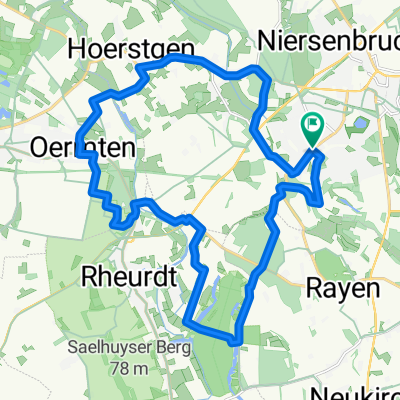
Overview
About this route
Die Route führt über Repelen, Eick-Ost, Lohmannsheide, Baerl, Homberg, Essenberg, Rheinhausen, Hochemmerich, Hochfeld, Wanheimerort, vorbei am Waldfriedhof in Richtung Wedau Regattabahn Süd. Entlang der Regattabahn zum MSV Stadion, von dort über Krupp und Koloniestraße Parallel zur Bahntrasse in den Duisburger Stadtwald bis zur Wolfsburg, bis dahin gilt es einen bissigen Anstieg zu bewältigen.Über die Hochfelderstr. geht es weiter bis zur Duisburger Str. im Mühlheimer Stadtteil Speldorf. Jetzt ist es nicht mehr weit bis zu Wasserbahnhof in Mühlheim. Von dort aus geht es zurück an der Stadthalle vorbei durch den MÜGA Park in Richtung Styrumer Brücke bis zum Wassserturm Aquarius. Über die Moritzstraße geht es dann zurück durch die Ruhraue und den Ruhrpark in Richtung Ruhrort. Nachdem wir die Autobahnbrücke der A3 unterquert haben geht es über die Brücke des Verbindungs Kanales über Pontwert unweigerlich in Richtung Ruhrort. Nach einem Radler und einem kleinen Snak auf der Mühlenweide, geht es über Laar, Beekerwerth, Haus Knipp Brücke, durch den Baerler Busch über die Verbandsstraße zurück an den Pattberg.
- -:--
- Duration
- 73.2 km
- Distance
- 138 m
- Ascent
- 134 m
- Descent
- ---
- Avg. speed
- ---
- Max. altitude

Continue with Bikemap
Use, edit, or download this cycling route
You would like to ride Moers, Wedau, Mühlheim- Wasserbahnhof, Ruhrort, Moers or customize it for your own trip? Here is what you can do with this Bikemap route:
Free features
- Save this route as favorite or in collections
- Copy & plan your own version of this route
- Sync your route with Garmin or Wahoo
Premium features
Free trial for 3 days, or one-time payment. More about Bikemap Premium.
- Navigate this route on iOS & Android
- Export a GPX / KML file of this route
- Create your custom printout (try it for free)
- Download this route for offline navigation
Discover more Premium features.
Get Bikemap PremiumFrom our community
Other popular routes starting in Kamp-Lintfort
 Die Leucht-Route
- Distance
- 24.8 km
- Ascent
- 101 m
- Descent
- 103 m
- Location
- Kamp-Lintfort, North Rhine-Westphalia, Germany
 Die Leucht 3
- Distance
- 32 km
- Ascent
- 123 m
- Descent
- 125 m
- Location
- Kamp-Lintfort, North Rhine-Westphalia, Germany
 Sakrale Bauten am Niederrhein
- Distance
- 63.5 km
- Ascent
- 124 m
- Descent
- 167 m
- Location
- Kamp-Lintfort, North Rhine-Westphalia, Germany
 Route Kohlenhuk
- Distance
- 26.1 km
- Ascent
- 97 m
- Descent
- 98 m
- Location
- Kamp-Lintfort, North Rhine-Westphalia, Germany
 Drei Haldentour
- Distance
- 35.7 km
- Ascent
- 221 m
- Descent
- 223 m
- Location
- Kamp-Lintfort, North Rhine-Westphalia, Germany
 Kamp-Lintfort-Kempen-Straelen-Kamp-Lintfort
- Distance
- 88.5 km
- Ascent
- 100 m
- Descent
- 100 m
- Location
- Kamp-Lintfort, North Rhine-Westphalia, Germany
 Lintfort - Oermter Berg - Lintfort
- Distance
- 23.3 km
- Ascent
- 86 m
- Descent
- 85 m
- Location
- Kamp-Lintfort, North Rhine-Westphalia, Germany
 Frankys Runde, Pattberg, Homberg,Essenberg, Kaßlerfeld, Walsum, Orsoy, Budberg, Pattberg
- Distance
- 52.5 km
- Ascent
- 124 m
- Descent
- 122 m
- Location
- Kamp-Lintfort, North Rhine-Westphalia, Germany
Open it in the app