
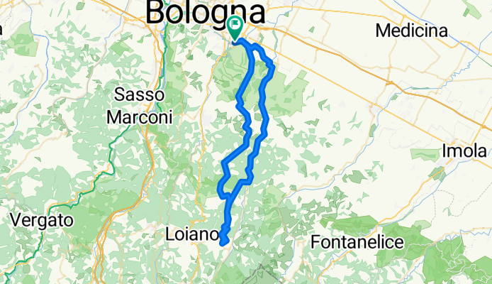
Bologna -Monte Bibele-Idice
A cycling route starting in Ponticella, Emilia-Romagna, Italy.
Overview
About this route
dal parco dei cedri lungo la val di zena si sale a monte bibele poi si torna da quinzano. prima del monte dlele formiche si scende nella valle dell'idice e alla noce si prende la ciclabile sx fino a pizzocalvo per poi tornar ea bologna con le ciclabile attraverso san lazzaro e parco dei cedri a bologna
- -:--
- Duration
- 65.1 km
- Distance
- 554 m
- Ascent
- 557 m
- Descent
- ---
- Avg. speed
- ---
- Max. altitude
Route quality
Waytypes & surfaces along the route
Waytypes
Road
31.7 km
(49 %)
Cycleway
8 km
(12 %)
Surfaces
Paved
34.3 km
(53 %)
Unpaved
13.7 km
(21 %)
Asphalt
33.9 km
(52 %)
Ground
5.8 km
(9 %)
Continue with Bikemap
Use, edit, or download this cycling route
You would like to ride Bologna -Monte Bibele-Idice or customize it for your own trip? Here is what you can do with this Bikemap route:
Free features
- Save this route as favorite or in collections
- Copy & plan your own version of this route
- Sync your route with Garmin or Wahoo
Premium features
Free trial for 3 days, or one-time payment. More about Bikemap Premium.
- Navigate this route on iOS & Android
- Export a GPX / KML file of this route
- Create your custom printout (try it for free)
- Download this route for offline navigation
Discover more Premium features.
Get Bikemap PremiumFrom our community
Other popular routes starting in Ponticella
 nordic colli classico lungo
- Distance
- 10.4 km
- Ascent
- 226 m
- Descent
- 227 m
- Location
- Ponticella, Emilia-Romagna, Italy
 1.1 San Lazzaro di Savena - Modena
- Distance
- 57.5 km
- Ascent
- 46 m
- Descent
- 95 m
- Location
- Ponticella, Emilia-Romagna, Italy
 colli bolognesi
- Distance
- 25.3 km
- Ascent
- 470 m
- Descent
- 470 m
- Location
- Ponticella, Emilia-Romagna, Italy
 Anello S. Ruffillo - Monte Donato - Rizzoli
- Distance
- 15.3 km
- Ascent
- 421 m
- Descent
- 424 m
- Location
- Ponticella, Emilia-Romagna, Italy
 Bologna -Monte Bibele-Idice
- Distance
- 65.1 km
- Ascent
- 554 m
- Descent
- 557 m
- Location
- Ponticella, Emilia-Romagna, Italy
 Montebello Gaibola Croara Ponticella
- Distance
- 20 km
- Ascent
- 370 m
- Descent
- 370 m
- Location
- Ponticella, Emilia-Romagna, Italy
 Montecalvo-Croara
- Distance
- 18.3 km
- Ascent
- 453 m
- Descent
- 453 m
- Location
- Ponticella, Emilia-Romagna, Italy
 anello Parco Monte di Paderno (modificato)
- Distance
- 28 km
- Ascent
- 754 m
- Descent
- 754 m
- Location
- Ponticella, Emilia-Romagna, Italy
Open it in the app