

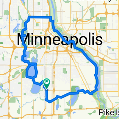
B2B00009 Rchfld>DwntwnMpls via Hiawatha
A cycling route starting in Richfield, Minnesota, United States.
Overview
About this route
B2B Route Request 00009
- -:--
- Duration
- 21.5 km
- Distance
- 29 m
- Ascent
- 29 m
- Descent
- ---
- Avg. speed
- 260 m
- Max. altitude
Route quality
Waytypes & surfaces along the route
Waytypes
Cycleway
8.7 km
(40 %)
Road
5.6 km
(26 %)
Surfaces
Paved
13.8 km
(64 %)
Asphalt
12.4 km
(58 %)
Paved (undefined)
1.3 km
(6 %)
Route highlights
Points of interest along the route
Point of interest after 2.5 km
Alternative Route: Use Portland and Park. Portland and Park both have on-street bike lanes beginning at 46th Street. Removes some distance and adds more traffic interaction.
Point of interest after 12.3 km
Alternative Route: =Continue Mississippi River Blvd and rejoin the route via the Greenway. Adds distance but cuts traffic interaction.
Continue with Bikemap
Use, edit, or download this cycling route
You would like to ride B2B00009 Rchfld>DwntwnMpls via Hiawatha or customize it for your own trip? Here is what you can do with this Bikemap route:
Free features
- Save this route as favorite or in collections
- Copy & plan your own version of this route
- Sync your route with Garmin or Wahoo
Premium features
Free trial for 3 days, or one-time payment. More about Bikemap Premium.
- Navigate this route on iOS & Android
- Export a GPX / KML file of this route
- Create your custom printout (try it for free)
- Download this route for offline navigation
Discover more Premium features.
Get Bikemap PremiumFrom our community
Other popular routes starting in Richfield
 B2B00114 55409 >55414 via Park Ave and stone arch bridge
- Distance
- 9 km
- Ascent
- 48 m
- Descent
- 57 m
- Location
- Richfield, Minnesota, United States
 B2B00001 55419 > 55416 via Lake Harriet, 38th, France
- Distance
- 8.4 km
- Ascent
- 75 m
- Descent
- 76 m
- Location
- Richfield, Minnesota, United States
 MoA - Grand Route - MoA
- Distance
- 61.9 km
- Ascent
- 156 m
- Descent
- 158 m
- Location
- Richfield, Minnesota, United States
 30 miler
- Distance
- 48.5 km
- Ascent
- 308 m
- Descent
- 310 m
- Location
- Richfield, Minnesota, United States
 31 Miles South to North, to Victory Memorial & Minnehaha
- Distance
- 50.9 km
- Ascent
- 124 m
- Descent
- 124 m
- Location
- Richfield, Minnesota, United States
 the Bike & Bistro's premiere tour
- Distance
- 6.7 km
- Ascent
- 26 m
- Descent
- 9 m
- Location
- Richfield, Minnesota, United States
 B2B00920 55407>55438 via Portland, Mnnha Pwy, Logan, Hylund Prk
- Distance
- 23.7 km
- Ascent
- 98 m
- Descent
- 95 m
- Location
- Richfield, Minnesota, United States
 Perfect Circle Minneapolis Bike Route
- Distance
- 36.4 km
- Ascent
- 117 m
- Descent
- 117 m
- Location
- Richfield, Minnesota, United States
Open it in the app