
Georgsheil, Ligusterweg
A cycling route starting in Rechtsupweg, Lower Saxony, Germany.
Overview
About this route
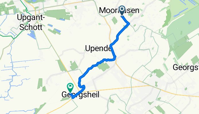
From Moorhusen to Georgsheil, Ligusterweg, (from Victorbur along the canal).
- -:--
- Duration
- 8.8 km
- Distance
- 0 m
- Ascent
- 0 m
- Descent
- ---
- Avg. speed
- ---
- Max. altitude
Route quality
Waytypes & surfaces along the route
Waytypes
Path
8.1 km
(92 %)
Quiet road
0.6 km
(7 %)
Surfaces
Paved
1.4 km
(16 %)
Unpaved
0.7 km
(8 %)
Asphalt
1.4 km
(16 %)
Pebblestone
0.7 km
(8 %)
Undefined
6.7 km
(76 %)
Continue with Bikemap
Use, edit, or download this cycling route
You would like to ride Georgsheil, Ligusterweg or customize it for your own trip? Here is what you can do with this Bikemap route:
Free features
- Save this route as favorite or in collections
- Copy & plan your own version of this route
- Sync your route with Garmin or Wahoo
Premium features
Free trial for 3 days, or one-time payment. More about Bikemap Premium.
- Navigate this route on iOS & Android
- Export a GPX / KML file of this route
- Create your custom printout (try it for free)
- Download this route for offline navigation
Discover more Premium features.
Get Bikemap PremiumFrom our community
Other popular routes starting in Rechtsupweg
 Runde ums Große Meer
- Distance
- 38.1 km
- Ascent
- 0 m
- Descent
- 0 m
- Location
- Rechtsupweg, Lower Saxony, Germany
 Rechtsupweg, Baumstraße 28 (über Westermoordorf)
- Distance
- 15.7 km
- Ascent
- 0 m
- Descent
- 0 m
- Location
- Rechtsupweg, Lower Saxony, Germany
 Großheide/Rundtour 2
- Distance
- 21.7 km
- Ascent
- 15 m
- Descent
- 17 m
- Location
- Rechtsupweg, Lower Saxony, Germany
 Runde Grpßheide 28 km
- Distance
- 26.3 km
- Ascent
- 28 m
- Descent
- 34 m
- Location
- Rechtsupweg, Lower Saxony, Germany
 Osterupgant, Aldi
- Distance
- 6.5 km
- Ascent
- 0 m
- Descent
- 0 m
- Location
- Rechtsupweg, Lower Saxony, Germany
 Tannenhausen/Rundtour 3
- Distance
- 30.4 km
- Ascent
- 16 m
- Descent
- 16 m
- Location
- Rechtsupweg, Lower Saxony, Germany
 Georgsheil, Ligusterweg
- Distance
- 8.8 km
- Ascent
- 0 m
- Descent
- 0 m
- Location
- Rechtsupweg, Lower Saxony, Germany
 Nadörst, Treidelpad/Rundtour 3
- Distance
- 28.6 km
- Ascent
- 11 m
- Descent
- 13 m
- Location
- Rechtsupweg, Lower Saxony, Germany
Open it in the app