

Mußbach-Weinbiet-Totenkopfhütte-Mußbach
A cycling route starting in Neustadt an der Weinstraße, Rhineland-Palatinate, Germany.
Overview
About this route
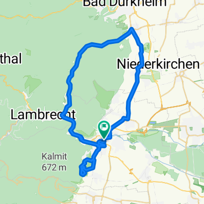
Very beautiful forest paths lead to the Weinbiet. At the beginning of the tour, you will still meet many hikers. From the Weinbiet downhill, you ride a very nice trail. The rest goes over a gravel track (another short trail) up to the Wolfsburg ruin. Down to Neustadt. Up from Königsmühle to Totenkopfhütte. Alongside the road, you can follow a very nice hiking path here. The path soon turns into a forest road that leads to Totenkopfhütte. From Totenkopfhütte, it goes alongside the road towards Kalmit. At the intersection towards Kalmit, take the hiking trail towards St. Martin. Through St. Martin and along the vineyards back to Neustadt and then to Mußbach. Along the route, you will find plenty of opportunities to stop for refreshments.
- -:--
- Duration
- 44.8 km
- Distance
- 873 m
- Ascent
- 873 m
- Descent
- ---
- Avg. speed
- ---
- Max. altitude
Continue with Bikemap
Use, edit, or download this cycling route
You would like to ride Mußbach-Weinbiet-Totenkopfhütte-Mußbach or customize it for your own trip? Here is what you can do with this Bikemap route:
Free features
- Save this route as favorite or in collections
- Copy & plan your own version of this route
- Sync your route with Garmin or Wahoo
Premium features
Free trial for 3 days, or one-time payment. More about Bikemap Premium.
- Navigate this route on iOS & Android
- Export a GPX / KML file of this route
- Create your custom printout (try it for free)
- Download this route for offline navigation
Discover more Premium features.
Get Bikemap PremiumFrom our community
Other popular routes starting in Neustadt an der Weinstraße
 BRT2019-Fr: Durch den Gemüsegarten Deutschlands - RTF des BRT2019-Fr - 48 km Strecke
- Distance
- 48.7 km
- Ascent
- 645 m
- Descent
- 644 m
- Location
- Neustadt an der Weinstraße, Rhineland-Palatinate, Germany
 BRT2019-Sa: Zur Radrennbahn und zum Rhein - 50 km Strecke
- Distance
- 50.3 km
- Ascent
- 82 m
- Descent
- 82 m
- Location
- Neustadt an der Weinstraße, Rhineland-Palatinate, Germany
 Pfalz 2015
- Distance
- 35.9 km
- Ascent
- 1,038 m
- Descent
- 1,038 m
- Location
- Neustadt an der Weinstraße, Rhineland-Palatinate, Germany
 Kalmit-HohenLog Tour
- Distance
- 47.2 km
- Ascent
- 1,350 m
- Descent
- 1,350 m
- Location
- Neustadt an der Weinstraße, Rhineland-Palatinate, Germany
 Hambacher Schloss, Wachenheimer Tal
- Distance
- 40.5 km
- Ascent
- 911 m
- Descent
- 907 m
- Location
- Neustadt an der Weinstraße, Rhineland-Palatinate, Germany
 Kalmitrunde
- Distance
- 25.9 km
- Ascent
- 808 m
- Descent
- 808 m
- Location
- Neustadt an der Weinstraße, Rhineland-Palatinate, Germany
 Große Pfälzerwald Runde
- Distance
- 141.3 km
- Ascent
- 796 m
- Descent
- 798 m
- Location
- Neustadt an der Weinstraße, Rhineland-Palatinate, Germany
 Weinbiet über Haardt
- Distance
- 11.6 km
- Ascent
- 424 m
- Descent
- 352 m
- Location
- Neustadt an der Weinstraße, Rhineland-Palatinate, Germany
Open it in the app