Schwalm-Naturschutzgebiet
A cycling route starting in Wegberg, North Rhine-Westphalia, Germany.
Overview
About this route
Tschüss Stress, willkommen Entspannung genießen Sie das weite Land mit seinen gepflegten Landgütern, alten Wassermühlen, weiten Wiesen und knorrigen Kopfweiden. Hier ist die Landschaft überall flach und fahrradfreundlich, auch für ungeübte Radler.
- -:--
- Duration
- 62.4 km
- Distance
- 78 m
- Ascent
- 99 m
- Descent
- ---
- Avg. speed
- ---
- Max. altitude
Route photos
Route quality
Waytypes & surfaces along the route
Waytypes
Quiet road
22.5 km
(36 %)
Track
19.3 km
(31 %)
Surfaces
Paved
16.9 km
(27 %)
Unpaved
26.2 km
(42 %)
Asphalt
15 km
(24 %)
Gravel
14.4 km
(23 %)
Route highlights
Points of interest along the route

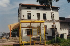
Photo after 0 km
Wegberg Bf

Photo after 3.7 km
Liebestunnel in Wegberg

Photo after 6 km
Schwalm Nähe Molzmühle

Accommodation after 11.4 km
Lütterlforst Mühle Lüttelforst 303, 41366 Schwalmtal Telefon:02163 571040

Photo after 16.5 km
Schlösschen am Hariksee

Accommodation after 17.7 km
Mühlrather Mühle am Hariksee Mühlrather Mühle 2, 41366 Schwalmtal Telefon:02163 5716276

Accommodation after 21.7 km
Brüggenermühle Burgwall 3, 41379 Brüggen Telefon:02163 6322

Photo after 27.6 km
swalm an die Venekotten

Photo after 35.4 km
Swalm

Photo after 40.1 km
Swalm Radweg

Photo after 59 km
Haus Galgevenn norrstraße 77, 41334 Nettetal Telefon:02157 6757
Continue with Bikemap
Use, edit, or download this cycling route
You would like to ride Schwalm-Naturschutzgebiet or customize it for your own trip? Here is what you can do with this Bikemap route:
Free features
- Save this route as favorite or in collections
- Copy & plan your own version of this route
- Sync your route with Garmin or Wahoo
Premium features
Free trial for 3 days, or one-time payment. More about Bikemap Premium.
- Navigate this route on iOS & Android
- Export a GPX / KML file of this route
- Create your custom printout (try it for free)
- Download this route for offline navigation
Discover more Premium features.
Get Bikemap PremiumFrom our community
Other popular routes starting in Wegberg
 Wegberg-Tetelrath
- Distance
- 20.8 km
- Ascent
- 77 m
- Descent
- 199 m
- Location
- Wegberg, North Rhine-Westphalia, Germany
 RTF Rheindahlen Zweiländerfahrt 72,7km
- Distance
- 72.6 km
- Ascent
- 159 m
- Descent
- 152 m
- Location
- Wegberg, North Rhine-Westphalia, Germany
 Dag 4 onsdag 4.7.18
- Distance
- 222.9 km
- Ascent
- 520 m
- Descent
- 478 m
- Location
- Wegberg, North Rhine-Westphalia, Germany
 Moorshoven - Brachter Wald
- Distance
- 68.5 km
- Ascent
- 309 m
- Descent
- 310 m
- Location
- Wegberg, North Rhine-Westphalia, Germany
 1.tag
1.tag- Distance
- 24 km
- Ascent
- 102 m
- Descent
- 52 m
- Location
- Wegberg, North Rhine-Westphalia, Germany
 50plus Route 2018
- Distance
- 37.1 km
- Ascent
- 109 m
- Descent
- 109 m
- Location
- Wegberg, North Rhine-Westphalia, Germany
 Schwalm-Nette Maas Radtour
- Distance
- 62.6 km
- Ascent
- 74 m
- Descent
- 116 m
- Location
- Wegberg, North Rhine-Westphalia, Germany
 Wegberg Garzweiler Tagebau
- Distance
- 21.1 km
- Ascent
- 76 m
- Descent
- 36 m
- Location
- Wegberg, North Rhine-Westphalia, Germany
Open it in the app


