

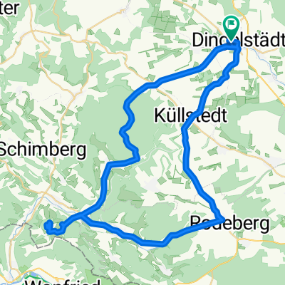
Dingelstädt - Bad Langensalza - Wiegleben
A cycling route starting in Dingelstädt, Thuringia, Germany.
Overview
About this route
Dingelstädt - Bad Langensalza - Wiegleben
- -:--
- Duration
- 52.8 km
- Distance
- 259 m
- Ascent
- 281 m
- Descent
- ---
- Avg. speed
- ---
- Max. altitude
Route quality
Waytypes & surfaces along the route
Waytypes
Busy road
13.6 km
(26 %)
Quiet road
11.2 km
(21 %)
Surfaces
Paved
44.9 km
(85 %)
Unpaved
1.2 km
(2 %)
Asphalt
43.7 km
(83 %)
Paving stones
1 km
(2 %)
Continue with Bikemap
Use, edit, or download this cycling route
You would like to ride Dingelstädt - Bad Langensalza - Wiegleben or customize it for your own trip? Here is what you can do with this Bikemap route:
Free features
- Save this route as favorite or in collections
- Copy & plan your own version of this route
- Sync your route with Garmin or Wahoo
Premium features
Free trial for 3 days, or one-time payment. More about Bikemap Premium.
- Navigate this route on iOS & Android
- Export a GPX / KML file of this route
- Create your custom printout (try it for free)
- Download this route for offline navigation
Discover more Premium features.
Get Bikemap PremiumFrom our community
Other popular routes starting in Dingelstädt
 Dingelstädt-Heyerode-BadSooden
- Distance
- 91.5 km
- Ascent
- 331 m
- Descent
- 512 m
- Location
- Dingelstädt, Thuringia, Germany
 Kanonenbahnradweg
- Distance
- 42.1 km
- Ascent
- 418 m
- Descent
- 419 m
- Location
- Dingelstädt, Thuringia, Germany
 27.07 25 kleine mittags runde
- Distance
- 18.2 km
- Ascent
- 185 m
- Descent
- 225 m
- Location
- Dingelstädt, Thuringia, Germany
 Unstrut-Werra-Runde
- Distance
- 88.2 km
- Ascent
- 596 m
- Descent
- 596 m
- Location
- Dingelstädt, Thuringia, Germany
 Unstrutradweg
- Distance
- 146.6 km
- Ascent
- 110 m
- Descent
- 358 m
- Location
- Dingelstädt, Thuringia, Germany
 Strecke Südeichsfeld
- Distance
- 48.2 km
- Ascent
- 788 m
- Descent
- 700 m
- Location
- Dingelstädt, Thuringia, Germany
 Trainingsrunde 3
- Distance
- 26.9 km
- Ascent
- 315 m
- Descent
- 311 m
- Location
- Dingelstädt, Thuringia, Germany
 Runde zur Burg Hanstein
- Distance
- 79.2 km
- Ascent
- 1,037 m
- Descent
- 997 m
- Location
- Dingelstädt, Thuringia, Germany
Open it in the app