

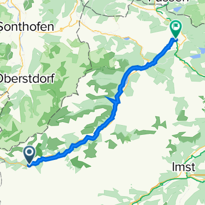
Lechtal - Steeg > Kienberg > Schlagwald > Bodenalpe > Erlachalpe
A cycling route starting in Steeg, Tyrol, Austria.
Overview
About this route
von steeg nach kaisers. an kaisers rechts unterhalb vorbei
- -:--
- Duration
- 13.8 km
- Distance
- 881 m
- Ascent
- 71 m
- Descent
- ---
- Avg. speed
- ---
- Max. altitude

Route quality
Waytypes & surfaces along the route
Waytypes
Track
8.6 km
(62 %)
Road
2.6 km
(19 %)
Surfaces
Paved
2.6 km
(19 %)
Unpaved
8.6 km
(62 %)
Gravel
8.6 km
(62 %)
Asphalt
2.6 km
(19 %)
Undefined
2.6 km
(19 %)
Continue with Bikemap
Use, edit, or download this cycling route
You would like to ride Lechtal - Steeg > Kienberg > Schlagwald > Bodenalpe > Erlachalpe or customize it for your own trip? Here is what you can do with this Bikemap route:
Free features
- Save this route as favorite or in collections
- Copy & plan your own version of this route
- Sync your route with Garmin or Wahoo
Premium features
Free trial for 3 days, or one-time payment. More about Bikemap Premium.
- Navigate this route on iOS & Android
- Export a GPX / KML file of this route
- Create your custom printout (try it for free)
- Download this route for offline navigation
Discover more Premium features.
Get Bikemap PremiumFrom our community
Other popular routes starting in Steeg
 Steeg - Elbigenalp
- Distance
- 14.9 km
- Ascent
- 51 m
- Descent
- 110 m
- Location
- Steeg, Tyrol, Austria
 Lech Radweg
- Distance
- 225.8 km
- Ascent
- 1,389 m
- Descent
- 2,149 m
- Location
- Steeg, Tyrol, Austria
 Lechtal - Inntal
- Distance
- 79.6 km
- Ascent
- 1,737 m
- Descent
- 1,984 m
- Location
- Steeg, Tyrol, Austria
 Lechtal
- Distance
- 65.5 km
- Ascent
- 79 m
- Descent
- 393 m
- Location
- Steeg, Tyrol, Austria
 Steg - Pflach
- Distance
- 55.1 km
- Ascent
- 24 m
- Descent
- 308 m
- Location
- Steeg, Tyrol, Austria
 Steeg 23, Steeg nach Mühler Straße 1, Reutte
- Distance
- 52.7 km
- Ascent
- 420 m
- Descent
- 680 m
- Location
- Steeg, Tyrol, Austria
 Almajur
- Distance
- 27.7 km
- Ascent
- 872 m
- Descent
- 872 m
- Location
- Steeg, Tyrol, Austria
 Steeg-HolzgauHöhenweg
- Distance
- 14.2 km
- Ascent
- 421 m
- Descent
- 421 m
- Location
- Steeg, Tyrol, Austria
Open it in the app