

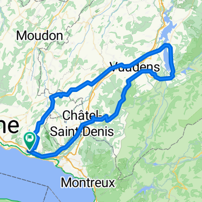
Chebrex-Dent de Jaman-Chebrex
A cycling route starting in Chexbres, Canton of Vaud, Switzerland.
Overview
About this route
Chebrex-Dent de Jaman-Chebrex
- -:--
- Duration
- 28.3 km
- Distance
- 1,186 m
- Ascent
- 238 m
- Descent
- ---
- Avg. speed
- ---
- Max. altitude

Route quality
Waytypes & surfaces along the route
Waytypes
Quiet road
9.9 km
(35 %)
Road
6.5 km
(23 %)
Surfaces
Paved
21.2 km
(75 %)
Asphalt
21.2 km
(75 %)
Undefined
7.1 km
(25 %)
Continue with Bikemap
Use, edit, or download this cycling route
You would like to ride Chebrex-Dent de Jaman-Chebrex or customize it for your own trip? Here is what you can do with this Bikemap route:
Free features
- Save this route as favorite or in collections
- Copy & plan your own version of this route
- Sync your route with Garmin or Wahoo
Premium features
Free trial for 3 days, or one-time payment. More about Bikemap Premium.
- Navigate this route on iOS & Android
- Export a GPX / KML file of this route
- Create your custom printout (try it for free)
- Download this route for offline navigation
Discover more Premium features.
Get Bikemap PremiumFrom our community
Other popular routes starting in Chexbres
 Chexbres - Lac de Gruyère - Rathvel - Chexbres
- Distance
- 85.9 km
- Ascent
- 1,094 m
- Descent
- 1,093 m
- Location
- Chexbres, Canton of Vaud, Switzerland
 Challenge Tour: Chexbres - Gstaad
- Distance
- 77.8 km
- Ascent
- 816 m
- Descent
- 291 m
- Location
- Chexbres, Canton of Vaud, Switzerland
 Chemin de la Planta 11, Rivaz nach Avenue de Chillon 21, Veytaux
- Distance
- 15.7 km
- Ascent
- 195 m
- Descent
- 272 m
- Location
- Chexbres, Canton of Vaud, Switzerland
 93_Tour du Mont Pélerin
- Distance
- 30.9 km
- Ascent
- 697 m
- Descent
- 697 m
- Location
- Chexbres, Canton of Vaud, Switzerland
 ch15-04-2 Chexbres - Vevey
- Distance
- 7 km
- Ascent
- 104 m
- Descent
- 285 m
- Location
- Chexbres, Canton of Vaud, Switzerland
 Balade en Gruyère
- Distance
- 91.6 km
- Ascent
- 876 m
- Descent
- 876 m
- Location
- Chexbres, Canton of Vaud, Switzerland
 Route stable en Puidoux-Gare
- Distance
- 18.9 km
- Ascent
- 633 m
- Descent
- 632 m
- Location
- Chexbres, Canton of Vaud, Switzerland
 Lavaux in autum
- Distance
- 22.4 km
- Ascent
- 489 m
- Descent
- 538 m
- Location
- Chexbres, Canton of Vaud, Switzerland
Open it in the app