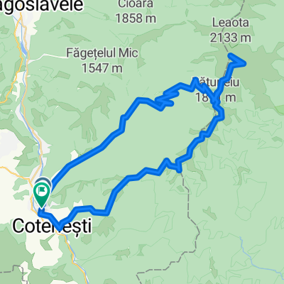
Stoienesti-Leaota-Muntele Fagetel- Stoienesti
A cycling route starting in Stoeneşti, Arges, Romania.
Overview
About this route
- -:--
- Duration
- 42.9 km
- Distance
- 1,712 m
- Ascent
- 1,712 m
- Descent
- ---
- Avg. speed
- ---
- Max. altitude
Route quality
Waytypes & surfaces along the route
Waytypes
Track
32.6 km
(76 %)
Quiet road
4.7 km
(11 %)
Surfaces
Paved
3 km
(7 %)
Unpaved
4.7 km
(11 %)
Unpaved (undefined)
3.9 km
(9 %)
Asphalt
3 km
(7 %)
Route highlights
Points of interest along the route
Point of interest after 36.7 km
de aici se poate sa coboram spre stanga, pe Valea Badenilro sau sa mergem in fata pe traseul facut de mine
Point of interest after 37.7 km
de aici se poate ori spre dreapta, pe un traseu mai practicat si mai scurt, ori pe traseul facut de mine, mai putin practicat
Continue with Bikemap
Use, edit, or download this cycling route
You would like to ride Stoienesti-Leaota-Muntele Fagetel- Stoienesti or customize it for your own trip? Here is what you can do with this Bikemap route:
Free features
- Save this route as favorite or in collections
- Copy & plan your own version of this route
- Sync your route with Garmin or Wahoo
Premium features
Free trial for 3 days, or one-time payment. More about Bikemap Premium.
- Navigate this route on iOS & Android
- Export a GPX / KML file of this route
- Create your custom printout (try it for free)
- Download this route for offline navigation
Discover more Premium features.
Get Bikemap PremiumFrom our community
Other popular routes starting in Stoeneşti
- Stoienesti-Leaota-Muntele Fagetel- Stoienesti
- Distance
- 42.9 km
- Ascent
- 1,712 m
- Descent
- 1,712 m
- Location
- Stoeneşti, Arges, Romania
- Badeni Leaota Cioara Dragoslavele
- Distance
- 51.3 km
- Ascent
- 1,711 m
- Descent
- 1,711 m
- Location
- Stoeneşti, Arges, Romania
- Muntii Leaota
- Distance
- 47 km
- Ascent
- 1,518 m
- Descent
- 1,516 m
- Location
- Stoeneşti, Arges, Romania
- Leaota peak by bike
- Distance
- 59.3 km
- Ascent
- 1,752 m
- Descent
- 1,752 m
- Location
- Stoeneşti, Arges, Romania
- Valea Badenilor-Vf. Cioara-retur nov 2019
- Distance
- 27.8 km
- Ascent
- 1,372 m
- Descent
- 1,369 m
- Location
- Stoeneşti, Arges, Romania
- Stoienești, Valea Bădenilor, Vârful Leaota, Cheile Grădiștei, Traseu 3 munti, prima zi
- Distance
- 44.1 km
- Ascent
- 1,649 m
- Descent
- 959 m
- Location
- Stoeneşti, Arges, Romania
- Valea Badenilor - Varf Leaota
- Distance
- 44.5 km
- Ascent
- 0 m
- Descent
- 0 m
- Location
- Stoeneşti, Arges, Romania
- E/// Tura Leaota
- Distance
- 48.5 km
- Ascent
- 1,546 m
- Descent
- 1,543 m
- Location
- Stoeneşti, Arges, Romania
Open it in the app