

Transalp Etappe 6
A cycling route starting in San Bernardo, Trentino-Alto Adige, Italy.
Overview
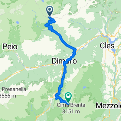
About this route
From Haselgruber Hütte to Rifugio Graffer
- -:--
- Duration
- 43.6 km
- Distance
- 1,739 m
- Ascent
- 1,728 m
- Descent
- ---
- Avg. speed
- ---
- Max. altitude
Route highlights
Points of interest along the route
Point of interest after 0 km
Haselgruber Hütte
Point of interest after 43.6 km
Rifugio Graffa
Continue with Bikemap
Use, edit, or download this cycling route
You would like to ride Transalp Etappe 6 or customize it for your own trip? Here is what you can do with this Bikemap route:
Free features
- Save this route as favorite or in collections
- Copy & plan your own version of this route
- Sync your route with Garmin or Wahoo
Premium features
Free trial for 3 days, or one-time payment. More about Bikemap Premium.
- Navigate this route on iOS & Android
- Export a GPX / KML file of this route
- Create your custom printout (try it for free)
- Download this route for offline navigation
Discover more Premium features.
Get Bikemap PremiumFrom our community
Other popular routes starting in San Bernardo
 Tag 5.
- Distance
- 76.5 km
- Ascent
- 1,093 m
- Descent
- 1,517 m
- Location
- San Bernardo, Trentino-Alto Adige, Italy
 AlpenX2017_Etappe5
- Distance
- 49.5 km
- Ascent
- 1,887 m
- Descent
- 1,887 m
- Location
- San Bernardo, Trentino-Alto Adige, Italy
 ritorno migliore
- Distance
- 156.4 km
- Ascent
- 1,849 m
- Descent
- 2,276 m
- Location
- San Bernardo, Trentino-Alto Adige, Italy
 Transalp 2015 Etappe 6 real.gpx
- Distance
- 49.5 km
- Ascent
- 1,648 m
- Descent
- 1,812 m
- Location
- San Bernardo, Trentino-Alto Adige, Italy
 Trans Alp 2013 - Psycho Cross - Etappe 6
- Distance
- 73.7 km
- Ascent
- 1,473 m
- Descent
- 2,084 m
- Location
- San Bernardo, Trentino-Alto Adige, Italy
 2018 Tag 2-1
- Distance
- 77.3 km
- Ascent
- 1,915 m
- Descent
- 2,253 m
- Location
- San Bernardo, Trentino-Alto Adige, Italy
 12 part 5/6 st. gertraud >>> refugio graffer
- Distance
- 52.6 km
- Ascent
- 2,549 m
- Descent
- 1,713 m
- Location
- San Bernardo, Trentino-Alto Adige, Italy
 VIA DELLE MALGHE NEL PARCO NAZIONALE DELLO STELVIO
- Distance
- 28.2 km
- Ascent
- 1,271 m
- Descent
- 1,271 m
- Location
- San Bernardo, Trentino-Alto Adige, Italy
Open it in the app