sehr leicht Albungen-Eschwege-Werratalsee-Rundweg
- 32.8 km
- 116 m
- 118 m
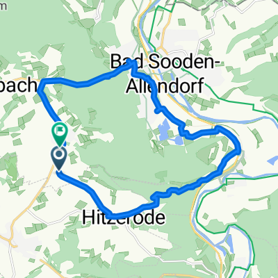
- Bad Sooden-Allendorf, Hesse, Germany
A cycling route starting in Bad Sooden-Allendorf, Hesse, Germany.
Overview
Around Ahrenberg
We start at the train station in Bad Sooden Allendorf and head towards the Sooden district. We pass under the railway line and ride along the bike path heading for "Söder Tor". We pass through the gate and reach "Weinreihe", where we turn right. At the end of "Weinreihe", we turn right onto "Am Haintor" street, which we follow to the end. We cross the street and ride past the cemetery until we reach the sign "Ahrenberg". We turn left into the forest and follow the path to "Ahrenberg". We cross the terrace (please push!) and ride down 200 meters through the parking lot. Now we turn right onto the Panoramaweg, which we follow all the way to Ellershausen. In Ellershausen, we cross the street, initially ride on the paved agricultural road and then follow the signs with the number "26". At a forest intersection, where there is a hunting stand, we turn right and ride downhill towards Oberrieden. After 200 meters in the village, we turn left onto Hessenweg. After a few meters uphill, the marking with the number "21" begins, which we now follow through some single trails and steep climbs, passing "Habichtstein" until we reach "Vollungsattel". We now turn left on the road, only to turn left again onto Wiesenweg after 50 meters. At the edge of the forest, the marking "x5" begins, where the path becomes quite challenging and not entirely safe. Therefore, it is recommended that inexperienced riders turn right onto the agricultural road at the edge of the forest. On both paths, we reach the road in Riedbachtal, where we first ride to the right. At the sign "ESW-203", we turn left into the forest and follow the "x5". Now follows a rather steep ascent, which we follow up to "Kuhlägerhütte". At the hut, we turn right, only to turn left again after a few meters. Now begins the marking towards "Ahrenberg", which we follow until the inn. We cross the terrace (please push!) and ride back to Bad Sooden Allendorf along the hiking path.
created this 16 years ago
Route quality
Track
17.6 km
(68 %)
Path
2.8 km
(11 %)
Paved
3.9 km
(15 %)
Unpaved
19.4 km
(75 %)
Gravel
9.1 km
(35 %)
Ground
8 km
(31 %)
Continue with Bikemap
You would like to ride Bikeführer MTB "Rund um den Ahrenberg" or customize it for your own trip? Here is what you can do with this Bikemap route:
Free trial for 3 days, or one-time payment. More about Bikemap Premium.
Discover more Premium features.
Get Bikemap PremiumFrom our community
Open it in the app