

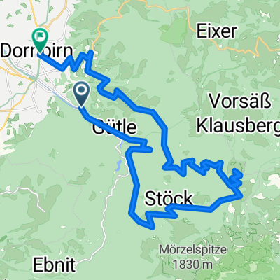
Dornbirn - Bödele - Fohramoos - Häfenberg
A cycling route starting in Dornbirn, Vorarlberg, Austria.
Overview
About this route
None
(cloned from route 1083907)
- -:--
- Duration
- 17.9 km
- Distance
- 762 m
- Ascent
- 764 m
- Descent
- ---
- Avg. speed
- ---
- Max. altitude
Route quality
Waytypes & surfaces along the route
Waytypes
Quiet road
4.8 km
(27 %)
Track
4.6 km
(26 %)
Surfaces
Paved
13.2 km
(74 %)
Unpaved
4.6 km
(26 %)
Asphalt
13.2 km
(74 %)
Gravel
4.6 km
(26 %)
Continue with Bikemap
Use, edit, or download this cycling route
You would like to ride Dornbirn - Bödele - Fohramoos - Häfenberg or customize it for your own trip? Here is what you can do with this Bikemap route:
Free features
- Save this route as favorite or in collections
- Copy & plan your own version of this route
- Sync your route with Garmin or Wahoo
Premium features
Free trial for 3 days, or one-time payment. More about Bikemap Premium.
- Navigate this route on iOS & Android
- Export a GPX / KML file of this route
- Create your custom printout (try it for free)
- Download this route for offline navigation
Discover more Premium features.
Get Bikemap PremiumFrom our community
Other popular routes starting in Dornbirn
 Dornbirn-Weissfluh-Kehlegg-Dornbirn
- Distance
- 30.1 km
- Ascent
- 968 m
- Descent
- 1,003 m
- Location
- Dornbirn, Vorarlberg, Austria
 Gütle-Rappenloch-Kobel-retour
- Distance
- 16 km
- Ascent
- 546 m
- Descent
- 548 m
- Location
- Dornbirn, Vorarlberg, Austria
 Dornbirn - Faschina – Bödele - Dornbirn
- Distance
- 99.9 km
- Ascent
- 1,874 m
- Descent
- 1,874 m
- Location
- Dornbirn, Vorarlberg, Austria
 Dannerbruck- Gütle- Niedere- Kobel und retour
- Distance
- 15.9 km
- Ascent
- 531 m
- Descent
- 533 m
- Location
- Dornbirn, Vorarlberg, Austria
 Dannerbruck - Gütle - Niedere - Kobelalpe und retour
- Distance
- 19.5 km
- Ascent
- 571 m
- Descent
- 575 m
- Location
- Dornbirn, Vorarlberg, Austria
 Dannersbruck- Eschenau- Palmern- Bantling- Stüben- Rädermacher- Dannersbruck
- Distance
- 14.6 km
- Ascent
- 441 m
- Descent
- 445 m
- Location
- Dornbirn, Vorarlberg, Austria
 Dannerbruck-Kehlegg-Schwefel-Schauner-Schwende Alp-Eisenharz-Dannerbruck😅
- Distance
- 13.8 km
- Ascent
- 595 m
- Descent
- 592 m
- Location
- Dornbirn, Vorarlberg, Austria
 Dannerbruck-Niedere-Kobel-Rudach-Rüttenen-Gechelbach-Dannerbruck
- Distance
- 17.9 km
- Ascent
- 1,092 m
- Descent
- 1,091 m
- Location
- Dornbirn, Vorarlberg, Austria
Open it in the app