303-Kronplatz-Schloss Bruneck by mnh
A cycling route starting in Gais, Trentino-Alto Adige, Italy.
Overview
About this route
Bruneck-Südtirol
- -:--
- Duration
- 45.6 km
- Distance
- 1,645 m
- Ascent
- 1,645 m
- Descent
- ---
- Avg. speed
- ---
- Avg. speed
Route quality
Waytypes & surfaces along the route
Waytypes
Undefined
45.6 km
(100 %)
Surfaces
Undefined
45.6 km
(100 %)
Continue with Bikemap
Use, edit, or download this cycling route
You would like to ride 303-Kronplatz-Schloss Bruneck by mnh or customize it for your own trip? Here is what you can do with this Bikemap route:
Free features
- Save this route as favorite or in collections
- Copy & plan your own version of this route
- Sync your route with Garmin or Wahoo
Premium features
Free trial for 3 days, or one-time payment. More about Bikemap Premium.
- Navigate this route on iOS & Android
- Export a GPX / KML file of this route
- Create your custom printout (try it for free)
- Download this route for offline navigation
Discover more Premium features.
Get Bikemap PremiumFrom our community
Other popular routes starting in Gais
- 302a Kronplatz-Panoramaweg-8er-Maria Saalen by mnh
- Distance
- 45.7 km
- Ascent
- 1,498 m
- Descent
- 1,498 m
- Location
- Gais, Trentino-Alto Adige, Italy
- Prato Piaza 93/1400
- Distance
- 93.5 km
- Ascent
- 1,676 m
- Descent
- 1,677 m
- Location
- Gais, Trentino-Alto Adige, Italy
- dolomiten Tag 8
- Distance
- 61.4 km
- Ascent
- 1,095 m
- Descent
- 1,012 m
- Location
- Gais, Trentino-Alto Adige, Italy
- Wieserhütte 88/1430
- Distance
- 44.6 km
- Ascent
- 1,959 m
- Descent
- 938 m
- Location
- Gais, Trentino-Alto Adige, Italy
- Kronplatz Tour 2012
- Distance
- 55.1 km
- Ascent
- 1,513 m
- Descent
- 1,518 m
- Location
- Gais, Trentino-Alto Adige, Italy
- Chemnitzer hutte 68/1750
- Distance
- 68.1 km
- Ascent
- 1,925 m
- Descent
- 1,926 m
- Location
- Gais, Trentino-Alto Adige, Italy
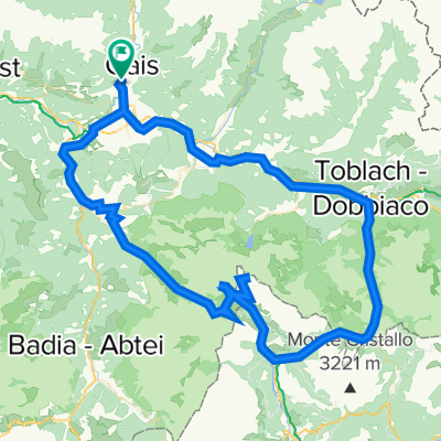
- Gais - Neves Stausee - Gais
- Distance
- 57 km
- Ascent
- 1,032 m
- Descent
- 1,026 m
- Location
- Gais, Trentino-Alto Adige, Italy
- Astjoch
- Distance
- 44.2 km
- Ascent
- 1,478 m
- Descent
- 1,472 m
- Location
- Gais, Trentino-Alto Adige, Italy