

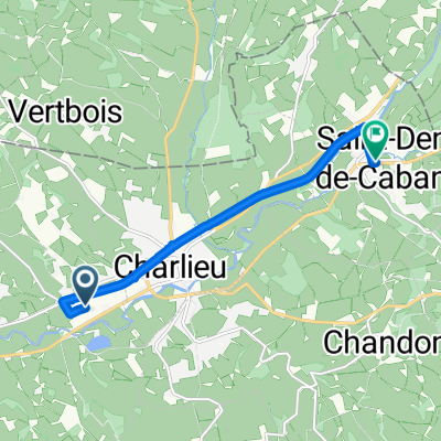
Charlieu
A cycling route starting in Charlieu, Auvergne-Rhône-Alpes, France.
Overview
About this route
1300 HM
- -:--
- Duration
- 88.1 km
- Distance
- 586 m
- Ascent
- 586 m
- Descent
- ---
- Avg. speed
- ---
- Max. altitude
Route quality
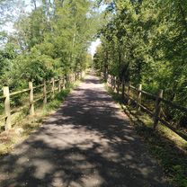
Waytypes & surfaces along the route
Waytypes
Quiet road
40.5 km
(46 %)
Road
35.2 km
(40 %)
Surfaces
Paved
28.2 km
(32 %)
Unpaved
0.9 km
(1 %)
Asphalt
28.2 km
(32 %)
Gravel
0.9 km
(1 %)
Undefined
59 km
(67 %)
Continue with Bikemap
Use, edit, or download this cycling route
You would like to ride Charlieu or customize it for your own trip? Here is what you can do with this Bikemap route:
Free features
- Save this route as favorite or in collections
- Copy & plan your own version of this route
- Split it into stages to create a multi-day tour
- Sync your route with Garmin or Wahoo
Premium features
Free trial for 3 days, or one-time payment. More about Bikemap Premium.
- Navigate this route on iOS & Android
- Export a GPX / KML file of this route
- Create your custom printout (try it for free)
- Download this route for offline navigation
Discover more Premium features.
Get Bikemap PremiumFrom our community
Other popular routes starting in Charlieu
 D16 Charlieu - St Just en Chevalet (64 km)
- Distance
- 64.2 km
- Ascent
- 714 m
- Descent
- 376 m
- Location
- Charlieu, Auvergne-Rhône-Alpes, France
 Rue Magellan, Saint-Nizier-sous-Charlieu à Rue de la République, Saint-Denis-de-Cabanne
- Distance
- 7.2 km
- Ascent
- 31 m
- Descent
- 12 m
- Location
- Charlieu, Auvergne-Rhône-Alpes, France
 france 200-10 charlieu-la tagnière
- Distance
- 115.4 km
- Ascent
- 771 m
- Descent
- 744 m
- Location
- Charlieu, Auvergne-Rhône-Alpes, France
 De Place Saint-Philibert 1, Charlieu à Place du Cours 21, Marcigny
- Distance
- 21 km
- Ascent
- 168 m
- Descent
- 225 m
- Location
- Charlieu, Auvergne-Rhône-Alpes, France
 Charlieu - Noiretable, Vollore Montagne, dag 6
- Distance
- 75.2 km
- Ascent
- 1,138 m
- Descent
- 564 m
- Location
- Charlieu, Auvergne-Rhône-Alpes, France
 Charlieu
- Distance
- 88.1 km
- Ascent
- 586 m
- Descent
- 586 m
- Location
- Charlieu, Auvergne-Rhône-Alpes, France
 Charlieu, Collanges
- Distance
- 70 km
- Ascent
- 113 m
- Descent
- 232 m
- Location
- Charlieu, Auvergne-Rhône-Alpes, France
 2eme tour avec toutouille pour préparer l'échappée scandinave
- Distance
- 15.2 km
- Ascent
- 199 m
- Descent
- 199 m
- Location
- Charlieu, Auvergne-Rhône-Alpes, France
Open it in the app