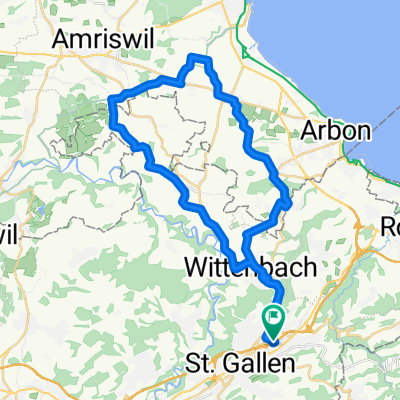
St. Gallen MTB Tour T1
A cycling route starting in St. Gallen, Canton of St. Gallen, Switzerland.
Overview
About this route
a
(cloned from route 2653817)- -:--
- Duration
- 34.7 km
- Distance
- 436 m
- Ascent
- 433 m
- Descent
- ---
- Avg. speed
- ---
- Avg. speed
Route quality
Waytypes & surfaces along the route
Waytypes
Quiet road
13 km
(37 %)
Busy road
6.7 km
(19 %)
Surfaces
Paved
21 km
(61 %)
Unpaved
7.3 km
(21 %)
Asphalt
17.7 km
(51 %)
Gravel
6.1 km
(17 %)
Continue with Bikemap
Use, edit, or download this cycling route
You would like to ride St. Gallen MTB Tour T1 or customize it for your own trip? Here is what you can do with this Bikemap route:
Free features
- Save this route as favorite or in collections
- Copy & plan your own version of this route
- Sync your route with Garmin or Wahoo
Premium features
Free trial for 3 days, or one-time payment. More about Bikemap Premium.
- Navigate this route on iOS & Android
- Export a GPX / KML file of this route
- Create your custom printout (try it for free)
- Download this route for offline navigation
Discover more Premium features.
Get Bikemap PremiumFrom our community
Other popular routes starting in St. Gallen
- Day 4 - St. Gallen to Konstanz
- Distance
- 58.9 km
- Ascent
- 115 m
- Descent
- 391 m
- Location
- St. Gallen, Canton of St. Gallen, Switzerland
- SG- Gäbris-Hohe Buche- Waldegg
- Distance
- 30 km
- Ascent
- 825 m
- Descent
- 825 m
- Location
- St. Gallen, Canton of St. Gallen, Switzerland
- Rosenberg Trail erweitert
- Distance
- 21.3 km
- Ascent
- 500 m
- Descent
- 500 m
- Location
- St. Gallen, Canton of St. Gallen, Switzerland
- appenzellerrundfahrt
- Distance
- 48.9 km
- Ascent
- 833 m
- Descent
- 768 m
- Location
- St. Gallen, Canton of St. Gallen, Switzerland
- Durch die Schweiz
- Distance
- 498.4 km
- Ascent
- 5,159 m
- Descent
- 5,456 m
- Location
- St. Gallen, Canton of St. Gallen, Switzerland
- St. Gallen-St. Anton-Trogen-St. Gallen
- Distance
- 29.7 km
- Ascent
- 828 m
- Descent
- 828 m
- Location
- St. Gallen, Canton of St. Gallen, Switzerland
- Sitterstrandweg
- Distance
- 50.6 km
- Ascent
- 1,234 m
- Descent
- 1,260 m
- Location
- St. Gallen, Canton of St. Gallen, Switzerland
- Rundfahrt Rosenberg-Erlenholz-Tannenberg-Ätschberg-Hafnersberg-Abtwil-St.Gallen
- Distance
- 27 km
- Ascent
- 775 m
- Descent
- 827 m
- Location
- St. Gallen, Canton of St. Gallen, Switzerland