

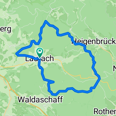
Laufach - Hörstein - Rückersbach - Johannesberg - Hösbach - Laufach
A cycling route starting in Laufach, Bavaria, Germany.
Overview
About this route
TEASI track
(cloned from route 2833616)
- -:--
- Duration
- 47.5 km
- Distance
- 430 m
- Ascent
- 428 m
- Descent
- ---
- Avg. speed
- ---
- Max. altitude
Route quality
Waytypes & surfaces along the route
Waytypes
Track
13.2 km
(28 %)
Quiet road
11.1 km
(23 %)
Surfaces
Paved
29.7 km
(63 %)
Unpaved
10.2 km
(22 %)
Asphalt
27.3 km
(58 %)
Gravel
8 km
(17 %)
Continue with Bikemap
Use, edit, or download this cycling route
You would like to ride Laufach - Hörstein - Rückersbach - Johannesberg - Hösbach - Laufach or customize it for your own trip? Here is what you can do with this Bikemap route:
Free features
- Save this route as favorite or in collections
- Copy & plan your own version of this route
- Sync your route with Garmin or Wahoo
Premium features
Free trial for 3 days, or one-time payment. More about Bikemap Premium.
- Navigate this route on iOS & Android
- Export a GPX / KML file of this route
- Create your custom printout (try it for free)
- Download this route for offline navigation
Discover more Premium features.
Get Bikemap PremiumFrom our community
Other popular routes starting in Laufach
 Laufachrunde
- Distance
- 28.9 km
- Ascent
- 514 m
- Descent
- 514 m
- Location
- Laufach, Bavaria, Germany
 Rund um den Schwarzkopf
- Distance
- 20.7 km
- Ascent
- 441 m
- Descent
- 442 m
- Location
- Laufach, Bavaria, Germany
 MTB Team Hain imSpessrt 40 km Runde
- Distance
- 39 km
- Ascent
- 588 m
- Descent
- 588 m
- Location
- Laufach, Bavaria, Germany
 LaufachRunde1
- Distance
- 9.3 km
- Ascent
- 237 m
- Descent
- 236 m
- Location
- Laufach, Bavaria, Germany
 Rennen MTB Team Hain im Spessart 2011
- Distance
- 35.8 km
- Ascent
- 689 m
- Descent
- 689 m
- Location
- Laufach, Bavaria, Germany
 RTV Spessart Tour 2011
- Distance
- 28.6 km
- Ascent
- 546 m
- Descent
- 546 m
- Location
- Laufach, Bavaria, Germany
 Kleine Renner Tour durch den Spessart
- Distance
- 34.5 km
- Ascent
- 587 m
- Descent
- 575 m
- Location
- Laufach, Bavaria, Germany
 Laufach heidelberg über Mudau
- Distance
- 155.4 km
- Ascent
- 1,177 m
- Descent
- 1,226 m
- Location
- Laufach, Bavaria, Germany
Open it in the app