

Normandie 4 - Carentan-Rundfahrt
A cycling route starting in Carentan, Normandy, France.
Overview
About this route
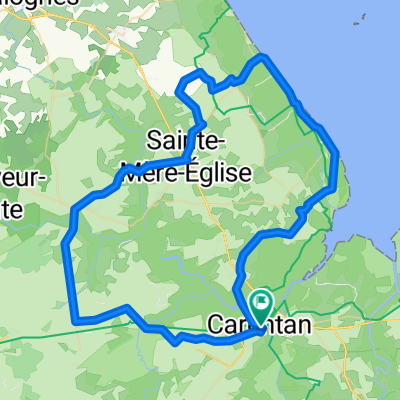
Startpunkt ist das durch die Schlacht um Carentan bekannte Städtchen gleichen Namens, die im juni 1944 statt fand. Von da geht es zuerst einige Kilometer der Hauptstrasse entlang bis Vierville, wo die Route rechts auf schmale, geteerte Strässchen abschwenkt. Nach Durchfahren einiger kleiner Dörfchen und Weiler bietet ein Zwischenhalt am Museum Utah-Beach Gelegenheit, etwas über die Landung der Alliierten in der Normandie zu erfahren und das Meer zu geniessen.
Nach einer kürzeren Strecke entlang der Meerkante führt die Route wieder landeinwärts bis zu den Verteidigungs-Geschütz-Anlagen der Deutschen in Azeville. Von dort geht es weiter nach Saint-Mère-Eglise, in dessen Restaurants ein nordfranzösisches Mittagessen geniessen und das Airborne-Museum besuchen kann, wenn man noch mehr Geschichtliches aus dem Zweiten Weltkrieg erfahren möchte. Von da aus führt der Weg etliche Kilometer über breitere meist doppelspurige Strassen in einem grossen Bogen durch etliche Ortschaften zurück zum Ausgangspunkt der Fahrt nach Carentan. Die Strecke ist mit gut 70 km von der Länge her nicht für Radanfänger geeignet, weist jedoch praktisch keine Höhenunterschiede auf.- -:--
- Duration
- 74.6 km
- Distance
- 185 m
- Ascent
- 185 m
- Descent
- ---
- Avg. speed
- ---
- Max. altitude
Route quality
Waytypes & surfaces along the route
Waytypes
Busy road
40 km
(54 %)
Road
20.6 km
(28 %)
Surfaces
Paved
60.3 km
(81 %)
Asphalt
60.3 km
(81 %)
Undefined
14.3 km
(19 %)
Continue with Bikemap
Use, edit, or download this cycling route
You would like to ride Normandie 4 - Carentan-Rundfahrt or customize it for your own trip? Here is what you can do with this Bikemap route:
Free features
- Save this route as favorite or in collections
- Copy & plan your own version of this route
- Sync your route with Garmin or Wahoo
Premium features
Free trial for 3 days, or one-time payment. More about Bikemap Premium.
- Navigate this route on iOS & Android
- Export a GPX / KML file of this route
- Create your custom printout (try it for free)
- Download this route for offline navigation
Discover more Premium features.
Get Bikemap PremiumFrom our community
Other popular routes starting in Carentan
 Carentan St Lo
- Distance
- 38 km
- Ascent
- 165 m
- Descent
- 163 m
- Location
- Carentan, Normandy, France
 Route Américaine, Carentan-les-Marais to Rue de la Hérode, Vierville-sur-Mer
- Distance
- 44.9 km
- Ascent
- 198 m
- Descent
- 168 m
- Location
- Carentan, Normandy, France
 Normandie 4 - Carentan-Rundfahrt
- Distance
- 74.6 km
- Ascent
- 185 m
- Descent
- 185 m
- Location
- Carentan, Normandy, France
 NORMANDY DAY 2 28 AUG 2014
- Distance
- 87.6 km
- Ascent
- 253 m
- Descent
- 257 m
- Location
- Carentan, Normandy, France
 Normandy 44
- Distance
- 204.1 km
- Ascent
- 1,075 m
- Descent
- 1,032 m
- Location
- Carentan, Normandy, France
 Cherbourg Campaign 1944
- Distance
- 117 km
- Ascent
- 536 m
- Descent
- 500 m
- Location
- Carentan, Normandy, France
 24 maggio
- Distance
- 89.4 km
- Ascent
- 903 m
- Descent
- 787 m
- Location
- Carentan, Normandy, France
 tandemXeurope 2009 - Day 5
- Distance
- 91.5 km
- Ascent
- 254 m
- Descent
- 253 m
- Location
- Carentan, Normandy, France
Open it in the app