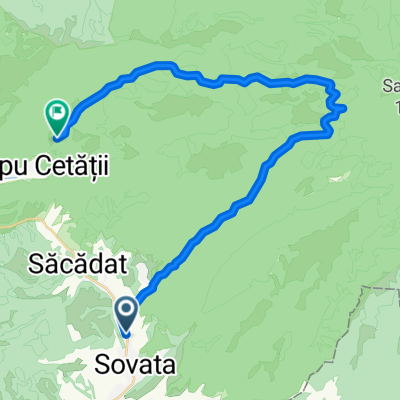
Brasov - Vatra Dornei - Ziua 3.2
A cycling route starting in Sovata, Judeţul Mureş, Romania.
Overview
About this route
Traseu I
Prima zi: Brasov-Sfantu Gheorghe-Tusnad-Miercurea Ciuc / aprox.: 97 km. A doua zi: Miercurea Ciuc-Baile Homorod-Odorheiu Secuiesc-Praid-Sovata / aprox.: 96 km. A treia zi: Sovata-Eremitu-Reghin-Deda-Neagra-Toplita / aprox.: 115 km. A patra zi: Toplita-Secu-Bilbor-Paltinis-Panaci-Saru Dornei-Dorna Arini-Vatra Dornei / aprox.: 70 km.- -:--
- Duration
- 114.4 km
- Distance
- 642 m
- Ascent
- 438 m
- Descent
- ---
- Avg. speed
- ---
- Avg. speed
Route highlights
Points of interest along the route
Point of interest after 1.2 km
Biserica fortificată din Hărman
Point of interest after 1.3 km
Salina Praid
Point of interest after 1.7 km
La Sovata Unde face Nicu armata
Point of interest after 1.8 km
lacul Ursu - Sovata
Point of interest after 89.9 km
Parcul Natural Defileul Muresului Superior
Continue with Bikemap
Use, edit, or download this cycling route
You would like to ride Brasov - Vatra Dornei - Ziua 3.2 or customize it for your own trip? Here is what you can do with this Bikemap route:
Free features
- Save this route as favorite or in collections
- Copy & plan your own version of this route
- Sync your route with Garmin or Wahoo
Premium features
Free trial for 3 days, or one-time payment. More about Bikemap Premium.
- Navigate this route on iOS & Android
- Export a GPX / KML file of this route
- Create your custom printout (try it for free)
- Download this route for offline navigation
Discover more Premium features.
Get Bikemap PremiumFrom our community
Other popular routes starting in Sovata
- Brasov - Vatra Dornei - Ziua 3.2
- Distance
- 114.4 km
- Ascent
- 642 m
- Descent
- 438 m
- Location
- Sovata, Judeţul Mureş, Romania
- Sovata - M. Nirajului - Tg Mureș - Eremitu (>) (RS200)
- Distance
- 114.2 km
- Ascent
- 897 m
- Descent
- 884 m
- Location
- Sovata, Judeţul Mureş, Romania
- Sovata-MiercureaNirajului-Tampa-TarguMures
- Distance
- 44.3 km
- Ascent
- 329 m
- Descent
- 395 m
- Location
- Sovata, Judeţul Mureş, Romania
- Nyugodt útvonal
- Distance
- 21.6 km
- Ascent
- 430 m
- Descent
- 471 m
- Location
- Sovata, Judeţul Mureş, Romania
- szovata-szereda-bekecs
- Distance
- 46.3 km
- Ascent
- 994 m
- Descent
- 388 m
- Location
- Sovata, Judeţul Mureş, Romania
- Strada Izvorului 6, Sovata to Strada Izvorului 5, Sovata
- Distance
- 18.5 km
- Ascent
- 215 m
- Descent
- 217 m
- Location
- Sovata, Judeţul Mureş, Romania
- Cserepeskő
- Distance
- 37.4 km
- Ascent
- 1,097 m
- Descent
- 1,082 m
- Location
- Sovata, Judeţul Mureş, Romania
- Bekecs
- Distance
- 33.3 km
- Ascent
- 759 m
- Descent
- 756 m
- Location
- Sovata, Judeţul Mureş, Romania
Open it in the app