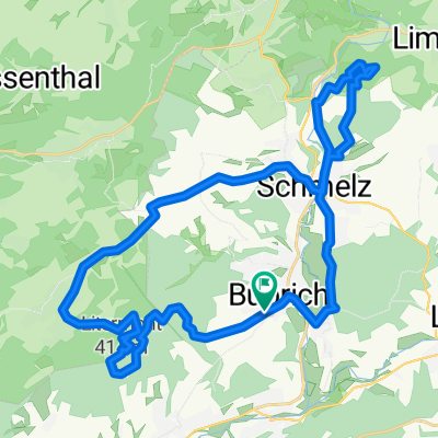
Limbach zu Burg Dagstuhl
A cycling route starting in Schmelz, Saarland, Germany.
Overview
About this route
Am Limbacher Sportweiher vorbei nach Büschfeld, von dort zur Burg Dagstuhl. Zurück am Noswendeler See vorbei nach Limbach.
(cloned from route 3133509) (cloned from route 3133511)- -:--
- Duration
- 21.2 km
- Distance
- 266 m
- Ascent
- 266 m
- Descent
- ---
- Avg. speed
- ---
- Avg. speed
Route quality
Waytypes & surfaces along the route
Waytypes
Road
9.1 km
(43 %)
Quiet road
4.4 km
(21 %)
Surfaces
Paved
11.4 km
(54 %)
Unpaved
3 km
(14 %)
Asphalt
11 km
(52 %)
Gravel
2.6 km
(12 %)
Route highlights
Points of interest along the route
Point of interest after 10.5 km
Schloss Dagstuhl
Point of interest after 10.6 km
Burg Dagstuhl
Point of interest after 13.9 km
Noswendler Stausee
Point of interest after 17.3 km
Saargummiwerk
Continue with Bikemap
Use, edit, or download this cycling route
You would like to ride Limbach zu Burg Dagstuhl or customize it for your own trip? Here is what you can do with this Bikemap route:
Free features
- Save this route as favorite or in collections
- Copy & plan your own version of this route
- Sync your route with Garmin or Wahoo
Premium features
Free trial for 3 days, or one-time payment. More about Bikemap Premium.
- Navigate this route on iOS & Android
- Export a GPX / KML file of this route
- Create your custom printout (try it for free)
- Download this route for offline navigation
Discover more Premium features.
Get Bikemap PremiumFrom our community
Other popular routes starting in Schmelz
- Schmelzer Runde
- Distance
- 14.9 km
- Ascent
- 209 m
- Descent
- 210 m
- Location
- Schmelz, Saarland, Germany
- Limbach zur Saarschleife
- Distance
- 65.1 km
- Ascent
- 622 m
- Descent
- 622 m
- Location
- Schmelz, Saarland, Germany
- Rund um Schmelz/ Hüttersdorf
- Distance
- 17.6 km
- Ascent
- 188 m
- Descent
- 190 m
- Location
- Schmelz, Saarland, Germany
- Wendelinus-Fahrt 2013 - RTF des RSC Haustadter Tal Reimsbach e.V. - 118 km Strecke
- Distance
- 114.7 km
- Ascent
- 1,313 m
- Descent
- 1,246 m
- Location
- Schmelz, Saarland, Germany
- 2019 Möven geführt 31km
- Distance
- 31.3 km
- Ascent
- 418 m
- Descent
- 418 m
- Location
- Schmelz, Saarland, Germany
- Gipfel-Trail
- Distance
- 33.9 km
- Ascent
- 509 m
- Descent
- 509 m
- Location
- Schmelz, Saarland, Germany
- schmelz-staustufe 46km 21,04,2016
- Distance
- 45.8 km
- Ascent
- 260 m
- Descent
- 258 m
- Location
- Schmelz, Saarland, Germany
- Limbach Hoxfels
- Distance
- 11.7 km
- Ascent
- 282 m
- Descent
- 281 m
- Location
- Schmelz, Saarland, Germany
Open it in the app