

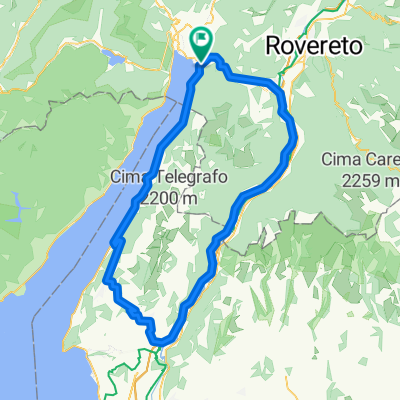
S.Giovanni Di Monte
A cycling route starting in Torbole sul Garda, Trentino-Alto Adige, Italy.
Overview
About this route
Very nice half-day tour.
It is recommended to start the loop via Padaro, riding uphill on good asphalt up to S. Giovanni al Monte (just under 1200m). From there, it descends back down to Calino via partly steep gravel paths.
The track then returns on asphalt through a medieval castle and past the beautiful Lake Tenno back to the main lake.
- -:--
- Duration
- 45.7 km
- Distance
- 1,164 m
- Ascent
- 1,164 m
- Descent
- ---
- Avg. speed
- ---
- Max. altitude
Continue with Bikemap
Use, edit, or download this cycling route
You would like to ride S.Giovanni Di Monte or customize it for your own trip? Here is what you can do with this Bikemap route:
Free features
- Save this route as favorite or in collections
- Copy & plan your own version of this route
- Sync your route with Garmin or Wahoo
Premium features
Free trial for 3 days, or one-time payment. More about Bikemap Premium.
- Navigate this route on iOS & Android
- Export a GPX / KML file of this route
- Create your custom printout (try it for free)
- Download this route for offline navigation
Discover more Premium features.
Get Bikemap PremiumFrom our community
Other popular routes starting in Torbole sul Garda
 Torbole - Altissimo
- Distance
- 52.4 km
- Ascent
- 2,267 m
- Descent
- 2,265 m
- Location
- Torbole sul Garda, Trentino-Alto Adige, Italy
 Torbole - C.Veronese - Mte. san Zeno
- Distance
- 94.7 km
- Ascent
- 929 m
- Descent
- 953 m
- Location
- Torbole sul Garda, Trentino-Alto Adige, Italy
 so aco
- Distance
- 119.3 km
- Ascent
- 1,725 m
- Descent
- 1,722 m
- Location
- Torbole sul Garda, Trentino-Alto Adige, Italy
 Via Benaco nach Piazzale Paolo Orsi
- Distance
- 20.1 km
- Ascent
- 262 m
- Descent
- 193 m
- Location
- Torbole sul Garda, Trentino-Alto Adige, Italy
 Torbole - Arco - Monte Brione - Torbole
- Distance
- 39.6 km
- Ascent
- 804 m
- Descent
- 803 m
- Location
- Torbole sul Garda, Trentino-Alto Adige, Italy
 Garda felső kör
- Distance
- 36.2 km
- Ascent
- 336 m
- Descent
- 333 m
- Location
- Torbole sul Garda, Trentino-Alto Adige, Italy
 Torbole_Arco_Mte.Baone_Arco_Riva
- Distance
- 23.6 km
- Ascent
- 418 m
- Descent
- 401 m
- Location
- Torbole sul Garda, Trentino-Alto Adige, Italy
 Monte Bondone I
- Distance
- 110.5 km
- Ascent
- 2,404 m
- Descent
- 2,403 m
- Location
- Torbole sul Garda, Trentino-Alto Adige, Italy
Open it in the app